

From the Open-Publishing Calendar
From the Open-Publishing Newswire
Indybay Feature
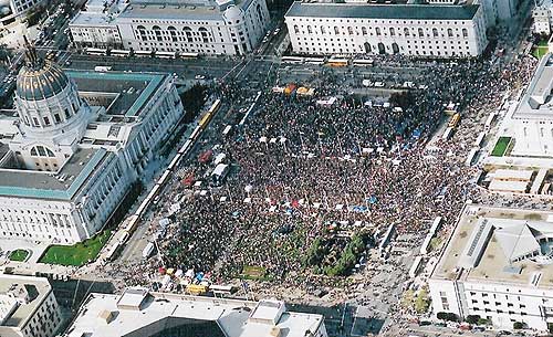
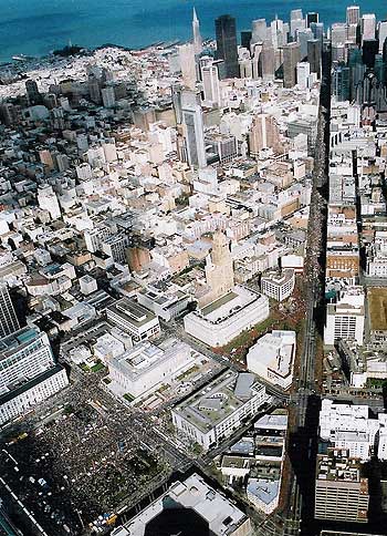
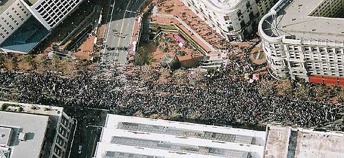
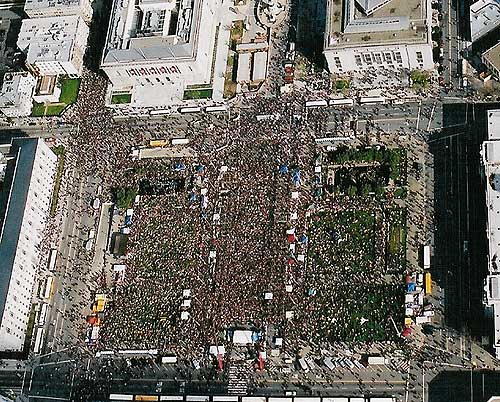
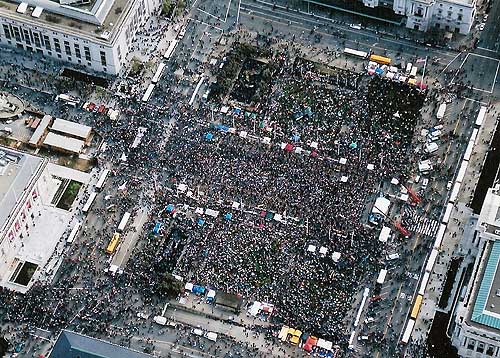
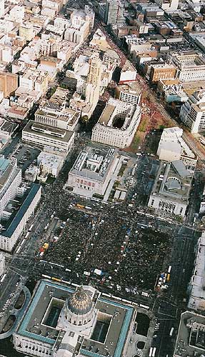
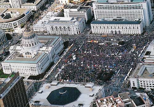
Aerial Photos of Feb 16 Anti-war March & Rally
Aerial photos of the February 16, 2003 mass protest against war on Iraq - "The world says no to war."
On a weekend in which millions took to the streets to oppose this unjust war, a quarter of a million people marched and rallied in San Francisco.
On a weekend in which millions took to the streets to oppose this unjust war, a quarter of a million people marched and rallied in San Francisco.
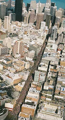
Many photos show tens of thousands crowding the SF Civic Center BEFORE the arrival of the main march. Select each for larger image.
Co-sponsored by United for Peace and Justice, Bay Area United Against War, International ANSWER, and Not in Our Name.
Photos by Aerial and Terrestrial Photos.
To view larger images:
http://www.notinourname.net/~bayarea/feb16air.htm
Co-sponsored by United for Peace and Justice, Bay Area United Against War, International ANSWER, and Not in Our Name.
Photos by Aerial and Terrestrial Photos.
To view larger images:
http://www.notinourname.net/~bayarea/feb16air.htm
For more information:
http://www.notinourname.net/~bayarea/feb16...
Add Your Comments
Comments
(Hide Comments)
The 3rd photo with the complete march route and the cloud shadow is stunning. Both the smaller and the larger versions. The larger version is here:
http://www.notinourname.net/~bayarea/images/F16_air/3.jpg
There are more overhead photos here:
http://www.indybay.org/news/2003/02/1575251
The photos above are from a San Francisco Chronicle article that gives a police estimate of 200,000. It is archived here:
http://www.indybay.org/news/2003/02/1575226.php and
http://groups.yahoo.com/group/cannabisaction/message/708
The link just above also has a longer compilation of links to Feb 14-16 2003 rally articles and overhead photos worldwide, 603 cities list, police estimates, other estimates of crowd sizes, news sites, news search, etc..
Links for the previous January 18 2003 San Francisco peace rally. Overhead photo links, police and other crowd size estimates, march route maps, etc.. San Francisco Chronicle article on it said: "On Saturday, police said 55,000 marched to Civic Center Plaza. A spokesman now says 150,000 is a safe estimate and 200,000 is possible."
http://groups.yahoo.com/group/cannabisaction/message/670 and
http://groups.yahoo.com/group/cannabisaction/message/669
603 cities listed (with links). Peace rallies worldwide Feb 14-16 2003:
http://unitedforpeace.org/article.php?id=725 --Original location.
http://groups.yahoo.com/group/cannabisaction/message/698 --Archived location.
Good overhead photos of some of the 603 rallies worldwide Feb 14-16 2003. Continuously-loading photo page compilation:
http://www.infoshop.org/inews/f15antiwar_news_pix1.html
Simple street map of the almost 2 mile march route. The red star on the map is at 7th and Market Street, San Francisco, California. The map is from MapQuest.com
http://www.indybay.org/uploads/street_map.gif and
http://boards.marihemp.com/boards/politics/media/45/45426.gif
I calculate the length of the (filled-to-capacity) San Francisco march route starting from the end of Market Street near the waterfront at Justin Herman Plaza, and then going all the way to the Civic Center Plaza, to be around 1.8 miles using the street map above.
Compare that with the length of march routes for these other big rallies:
London peace rally Feb 15 2003. Police estimate 750,000+. Observer UK article. Nonprofit newspaper.
http://groups.yahoo.com/group/cannabisaction/message/706
Police estimate 950,000 at Rome peace rally Feb 15 2003.
http://groups.yahoo.com/group/cannabisaction/message/701
The Rome article says
"Saturday's march, which covered nearly 15 km, began at midday, two hours before the scheduled time because so many early arrivals had amassed in the morning."
15 kilometers is 9.3 miles.
The map is from MapQuest.com and the red star on the map is at 7th and Market Street, San Francisco, California. Around where people turned off Market Street to go to Civic Center Plaza. The march started at the end of Market Street near the waterfront and Justin Herman Plaza.
![street_map.gif]()
This compilation of photo links also includes some good overhead photos:
http://www.punchdown.org/rvb/F15
I used Offline Commander to download them all in the background while browsing elsewhere. I now have them on my hard drive for fast access.
http://www.punchdown.org/rvb/F15
I used Offline Commander to download them all in the background while browsing elsewhere. I now have them on my hard drive for fast access.
It's great to see that there were so many people, rallying against the Amrican war politics towards Iraq....Tooooo bad nobody here in Italy was able to have access to reliable reports on the massive participation of America citizens to the protest!!!!!!!
This is exactly why we must embrace our own media. Our Independant media. Viva Indymedia!
Thank you to all who work at Indymedia for all your hard work. I'll continue to contribute what I can, when I can, and hope that other people will do so too. Through our collective awareness, we can overcome the disinformation.
Thank you to all who work at Indymedia for all your hard work. I'll continue to contribute what I can, when I can, and hope that other people will do so too. Through our collective awareness, we can overcome the disinformation.
These overhead photos have more detail because they are taken from buildings instead of from a helicopter:
http://www.indybay.org/news/2003/02/1575886.php
http://www.indybay.org/news/2003/02/1575886.php
San Francisco Chronicle article Feb 21 2003.
http://www.sfgate.com/cgi-bin/article.cgi?file=/c/a/2003/02/21/MN240732.DTL
"The series of images were shot in a 30-second sweep by the crew from Air Flight Service over the march and rally areas at 1:45 p.m. ... At the time the photographs were taken, many people had gathered in the [Civic Center] plaza, and the head of the march was at McAllister Street. The tail was near Sansome Street, and no side street was full enough to count, said Jack Barcelona, who runs the air photo firm."
McAllister Street is one of the streets where people could turn off Market Street to get to Civic Center Plaza.
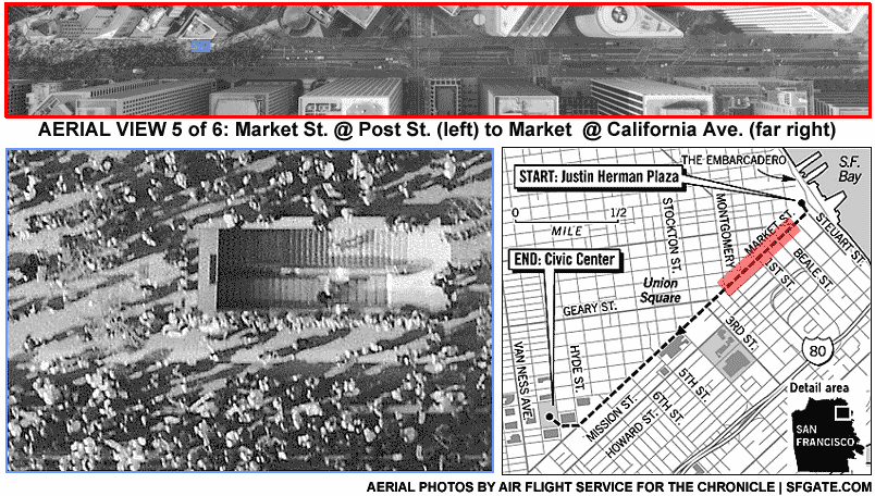
The caption for the previous photo was
"Frame 5 shows the march route along Market between Post St. and California Avenue (far right frame). In the inset enlargement, marchers walk past a BART entrance near Market and Sansome. SFGate.com & Chronicle Graphic."
The march route map in the collage is slightly incorrect. People turned off Market Street near McAllister or 7th Street. Not at 8th Street as the dashed march route indicates in the San Francisco Chronicle street map.
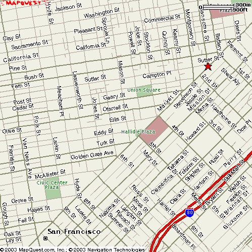
Here is another MapQuest.com map with the red star at Market and Sansome Street.
The distance from the end of the march at 1:45 PM at the intersection of Market and Sansome Street, and going just to the beginning of the Civic Center Plaza, is 1.2 miles.
The full march route starting from near the waterfront at Justin Herman Plaza was 1.8 miles.
The distance from the end of the march at 1:45 PM at the intersection of Market and Sansome Street, and going just to the beginning of the Civic Center Plaza, is 1.2 miles.
The full march route starting from near the waterfront at Justin Herman Plaza was 1.8 miles.
Caption:
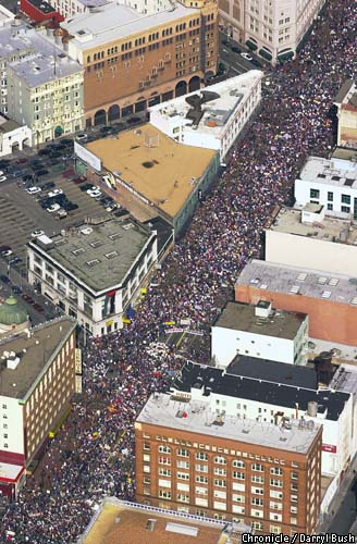
"An aerial photo taken at approximately 1:50 p.m. Sunday shows thousands marching along Market Street near the McAllister intersection (lower left of frame). Chronicle photo by Darryl Bush"
http://www.sfgate.com/cgi-bin/object.cgi?object=/chronicle/pictures/2003/02/17/mn_protestaerial17a_db.jpg&paper=chronicle&file=MN240732.DTL&directory=/c/a/2003/02/21&type=news
We are 100% volunteer and depend on your participation to sustain our efforts!
Donate

$110.00 donated
in the past month
Get Involved
If you'd like to help with maintaining or developing the website, contact us.
Publish
Publish your stories and upcoming events on Indybay.
Topics
More
Search Indybay's Archives
Advanced Search
►
▼
IMC Network