

From the Open-Publishing Calendar
From the Open-Publishing Newswire
Indybay Feature
Things You Cannot Hide Hunters Point Naval Shipyard Parcel G -The Explosive Truth!
The Navy proposes to explode six radiologically impacted buildings sited on radiation-contaminated soils and concrete at Hunters Point Naval Shipyard Federal Superfund Site Parcel G. The demolition will expose chemically contaminated hazardous waste throughout the Palou Avenue residentially zoned neighborhood — past playgrounds, schools, and churches to the transit and commercial center on 3rd Street.
Things You Cannot Hide
Hunters Point Naval Shipyard Parcel G -The Explosive Truth!
by Dr. Ahimsa Porter Sumchai
• • • • • • • • August 2025 • • • • • • • •
The Trump administration wants to dramatically withdraw the federal government from its traditional role of writing and enforcing environmental rules.
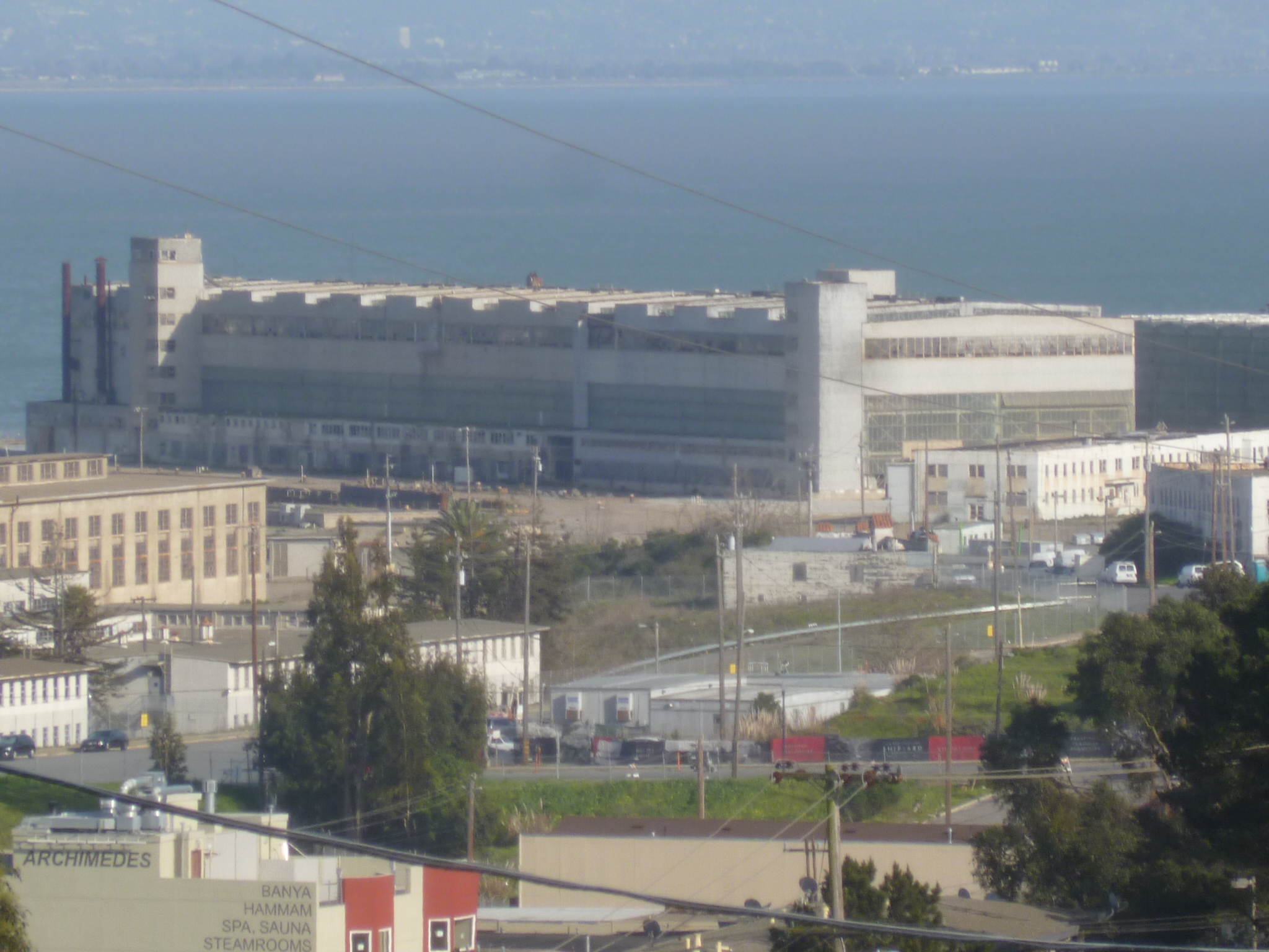
The photo above was taken from the western fence line of the Hunters Point Naval Shipyard overlooking Parcel G and the Gantry Crane, where demolition of MARSSIM Class 1 Radiation Contaminated Buildings is planned over the next six months.
Paraphrasing prolific science fiction author Frank Herbert’s quote in Dune Messiah from the Ancient Fremen saying:
“Four things cannot be hidden - love, smoke, a pillar of fire and” — allow me to add — Explosive Truth!
heat-map
Hunters Point Biomonitoring Heat Map created by GreenInfo Network and funded by CalEPA. GPS coordinates track the home or work address of residents and/or workers with radioactive biomarkers (ROC Cluster) detected in urinary assays and those diagnosed with radiogenic cancers - cancers proven by the Atomic Bomb Registry and Veterans Administration to be induced by exposure to ionizing radiation (RCC Cluster).
Environmental Systems Research Institute (ESRI) mapping reveals the heat of four independent cancer and chemical clusters tracked by the Hunters Point Community Toxic Registry. The clusters lie within 5000 feet or 0.97 miles of the Hunters Point Shipyard (HPNS) in Southeast San Francisco. The Hunters Point Community Toxic Registry is hosted by ArcGIS and powered by ESRI.
cac
HPS Citizens Advisory Committee
Navy Base Realignment and Closure (BRAC) Environmental Coordinator Michael Pound made the outrageous claim that the Navy scanned the buildings for radiation on Parcel G that are slated for explosive demolition — and that in Building 401, there was “None Detected.” This is impossible due to the presence of naturally occurring background radiation. This claim was made at a PowerPoint presentation. Pound presented an update at the Hunters Point Shipyard Citizen Advisory Committee on Monday, July 28, 2025. I became concerned that - like Pinocchio - his nose would hit the wall of the meeting room!
The Navy proposes to explode six radiologically impacted buildings sited on radiation-contaminated soils and concrete at Hunters Point Naval Shipyard Federal Superfund Site Parcel G. The demolition will expose chemically contaminated hazardous waste throughout the Palou Avenue residentially zoned neighborhood — past playgrounds, schools, and churches to the transit and commercial center on 3rd Street.
“We are beautiful people”
On July 28th, Pound confirmed the Navy intends to explode clouds of poisonous dust a quarter of a mile from Parcel A homes and condominiums and two miles from the 3rd Street transit corridor, near food trucks and a heavily trafficked industrial roadway. Then, the radioactive and chemically contaminated hazardous waste will be conveyed down Palou Avenue - past Oakdale playground and George Washington Carver Elementary School - to Third Street through a neighborhood zoned by San Francisco Planning as residential, ranked in the 95th to 100th percentile for air toxic exposures by CalEnviroScreen and EPA’s EJSCREEN.
UC-3
Palou Avenue in San Francisco’s Bayview neighborhood (94124) has a mix of residential zoning, primarily RH-1 and RH-2 for single-family and two-family homes. The Parcel G demolition zone at Spear Avenue - designated UC-1 - (right hand corner) courses west to Crisp Road - designated UC-3 - Crisp Road exits the base intersecting with the 1000 block of Palou coursing half a mile west to the major transit and commercial center at 3rd & Palou.
The Environmental Protection Agency’s EJSCREEN is an environmental justice mapping and screening tool that provides a nationally consistent dataset and approach for combining environmental and demographic indicators. EJSCREEN ranks the one-mile perimeter surrounding the Hunters Point Naval Shipyard in the 90th to 100th national percentile for nearly all environmental justice indices.
Multi-layer Map
The Hunters Point Community Toxic Registry Metadata Multilayer Exposure Map layers five distinct chemical and cancer clusters within 5000 feet of the Hunters Point Naval Shipyard Federal Superfund site. Created by GreenInfo Network and funded by CalEPA, the MetaData Exposure Map overlays the EPA EJSCREEN, CalEnviroScreen 4.0 and Disadvantaged Communities data for block groups. The ESRI map is programmed to zoom out five miles. The relative impact of environmental justice burden and disease compared to the region creates a bullseye mushrooming around Bayview Hunters Point.
Explosive demolition, or building implosion, is a specialized engineering field involving the strategic alignment of explosives used to trigger a controlled structural collapse. Explosives are positioned to weaken foundational supports, causing the building to fall inward.
exploding buildings
According to complaints filed in 2021 by Public Employees for Environmental Responsibility, the State of California allowed the US Department of Energy to dynamite two radioactive buildings without requiring dust control or notifying local authorities. The Santa Susana Demolition site, located 30 miles from downtown Los Angeles, is the site of a nuclear meltdown and multiple releases of radioactive and toxic chemicals.
Explosive demolitions spew particulate matter PM 2.5 and PM 10, a mixture of solid and liquid particles suspended in the air. PM2.5 and PM10 are two size-based categories of particulate matter that are of particular concern for human health. World War II era buildings located on Parcel G spew asbestos, lead, and carcinogenic heavy metals, compounding health hazards in the city neighborhood ranked highest in cardiorespiratory diseases, COVID-19 incidence, infant mortality, and Stage II breast cancer incidence and mortality.
A community at heightened risk from airborne particulates compounded by seasonal wildfires, construction dust, diesel particulates from trucks, RVs, school buses, and unregulated polluting industries. A maligned community with a documented indoor smoking incidence of only 4.5%.
smoking incidence rod
Additionally, Parcel G buildings, soil, groundwater, and concrete are documented to pose dangerous risks of exposure to cancer-causing chemicals and radionuclides in the Final 2009 Parcel G Record of Decision (ROD).
The Naval Facilities Engineering Systems Command (NAVFAC) Building Demolition Map documents Navy plans to demolish six buildings explosively, outlined in yellow, located on Parcel G: Buildings 401, 411, 439, 366, 351, and 351A. Building 401 is located at the heavily trafficked Spear Avenue (UC-1) across the street from residential Parcel A. Building 401 is clearly unsuitable for explosive demolition. The National Environmental Policy Act (NEPA) mandates that environmental review must analyze manual demolition and no demolition options.
parcel G map
Google Maps document that the Spear Avenue (UC-1) northern boundary of the Parcel G Demolition Site is a quarter of a mile from Hillpoint Park, Shipyard playground and 451 Donahue Street Condominiums on Parcel A.
401 Donahue
“Please add to the Executive Summary text that Parcel G has contained Cs-137 contamination due to the Navy’s activities.”
EPA Review of the Navy June 2018 Draft Parcel G Removal Site Evaluation Work Plan.
Photo taken 03/12/24 Hillpoint Park overlooking Drydock 4 and the historic Hunters Point Gantry Crane at Parcel G’s Spear Avenue/UC-1 northern border.
A production crew captured footage for the PBS/NOVA documentary Critical Condition at Hillpoint Park, overlooking Drydock 4 and the northern boundary of Parcel G at Spear Avenue. Food service trucks are parked against unfortified chain metal fences across the street from a neglected, uncovered Radiation Staging Yard, documented in this March 12, 2024 photo, captured by the author, submitted as a complaint and verified by the Office of the Navy Inspector General in Norfolk, Virginia.
staging fields
Footage captured at Hillpoint Park on March 12, 2024, from NOVA/PBS
documentary Critical Condition: Health in Black America.
stern memo
A sternly worded 2018 memo sent to the Navy by EPA documents that Cesium - 137 was detected in high concentrations in sewers along Cochrane Street near Spear Avenue in the photo above and documented in the 2004 Hunters Point Shipyard Historical Radiological Assessment.
“The 2004 HRA indicates Cesium - 137 was found at high concentrations in sediment from a manhole along Cochrane Street. The HRA documents the Navy used Cs-137, resulting in liquid waste and releases in Building 364 in piping, sinks, and the “peanut spill” behind the buildings. The HRA also documents in Table 5-1 that the Navy held five radioactive licenses with the Atomic Energy Commission for Cs-137, one for a quantity of 3,000 Curies and a separate quantity of 20 Curies.” EPA Review of the Navy June 2018 Draft Parcel G Removal Site Evaluation Work Plan
The Understanding of Consequences
chain link fence at shipyard
Unfortified chain link fence facing eastward toward the mighty historic Hunters Point Gantry Crane at the Hunters Point Naval Shipyard Federal Superfund Site.Photo: SF Bayview Newspaper Archives
“Ecology is the science of understanding of consequences.”—Frank Herbert - DUNE Chronicles
gantry crane map
Like a pillar of smoke and fire, many burning and unsolved questions are raised about the Navy proposal to demolish six radiologically impacted buildings on MARSSIM (Multi-Agency Radiation Survey and Site Investigation Manual) Class I contaminated Federal Superfund site Parcel G.
How did the Navy remediate buildings — located on the corridor to the Gun Mole Pier in a region the Nuclear Regulatory Commission calls “the loading point for nuclear waste” - to the degree that, when scanned for radionuclides of concern, there were “None Detected” in buildings slated for explosive demolition when it is estimated it will take 20,000 years to remediate Chernobyl?
Why does the Navy propose to explode Building 401 at the heavily trafficked intersection of Spear Avenue and H Street, across the street from Parcel A residences, playgrounds and food trucks? If Building 401 requires demolition, doesn’t it make common sense to manually demolish a building in a highly sensitive location?
guardian's shipyard article
How did Strontium-90 contamination, detected in above-background concentrations at 23 locations on Parcel G — as documented in a Freedom of Information Act request made by Public Employees for Environmental Responsibility — get cleaned up to concentrations below zero?
How did the leading global provider of consulting and engineering services, Tetra Tech, soil samples in a region where over 97% were determined to be fraudulent, get retested to levels of “None Detected” when BRAC Coordinator Michael Pound succinctly stated Parcel G radiological retesting is only 60% complete? (Presto Chango - in the Westside Observer 11/1/2024 by Dr. Ahimsa Sumchai.
The Navy achieved the seemingly impossible feat of retesting for radionuclides at Hunters Point Naval Shipyard and detecting concentrations less than zero. Amazingly, the Navy disappeared all of the Strontium - 90 detected in above-background concentrations in 10% of Parcel G samplings publicly reported by NAVFAC in 2018 — as well as all of the naturally occurring strontium in shipyard soils.
parcel map
Parcel Map and Planned Land Use Districts Map from
HPNS Fifth Five-Year Review. Mixed Use Residential
Development is sited on Parcel G at the Spear
Avenue intersection with I Street - designated UC-1.
This was accomplished by substituting a clean-up goal calculator called RESRAD (environmental contamination of RESidual RADioactive materials), built for the EPA Preliminary Remediation Goals agreed upon by regulators in the 2009 Parcel G ROD. In 2018, under the “smokescreen” of the Tetra Tech soil scandal, the Navy created a “glitch in the Matrix” by switching clean-up standards from the EPA preliminary remediation goals set and published in the 2009 Parcel G ROD - in violation of Federal Superfund Law!
Additionally, at Parcel G, the Navy substituted the CERCLA, the Comprehensive Environmental Response, Compensation, and Liability Act, enacted in 1980, also known as the Superfund law, authority of the 2009 Final Record of Decision for Parcel G with a 2017 document with a similar URL titled Final Record of Decision for Parcel G - Explanation of Significant Differences.
The 2017 document proposes significant differences in residential land use restrictions and the Parcel G remedy. In the Pounds 07/28/25 presentation, his opening slide misrepresents the Final Parcel G Record of Decision Explanation of Significant Differences — a document published in 2017 — as the original 2009 CERCLA-mandated ROD.
ecology quote
Document substitution, data manipulation, and violations of the Federal Superfund law are how Parcel G remediation is being achieved — at risks to life and safety of workers, contractors, and an estimated 23,000 residents within the one-mile perimeter of the Crisp Road entry — and the entire 3rd Street transit and commercial strip!
These burning questions demand answers! They cannot be hidden.
The Explosive Truth is that the Navy is engaged in concealment, document substitutions, data manipulation and Federal Superfund law violations in a flailing attempt to erase the radiological history of the Parcel G - a region best conceptualized as the western corridor to the Gun Mole Pier - described by the Nuclear Regulatory Commission as “the loading point for nuclear waste.”
The Explosive Truth is that Navy attempts to conceal and misrepresent the radiological history, contamination, and health risks documented in the Final 2009 Parcel G Record of Decision from the Building Demolition Plans, are patterned behaviors adding to the long list of Federal Superfund Violations the Navy is being sued for in Federal Court today.
radionuclides survey
The Explosive Truth is that the Navy’s concealment of shipyard building, soil and sediment contamination with radioactive and cancer-causing heavy metals is patterned behavior evident in the siting of the Artists Colony in the Parcel B Submarine Area, where sediment testing documents maximum concentrations of Cs-137, Cobalt-60, Plutonium 239/240, Radium-226, Strontium-90 and Uranium-235:
chain link fence at crane
The Explosive Truth is that Parcel G is a MARSSIM Class I Radiation Contaminated Property with historical documentation of Cesium-137 and Strontium-90 detections in high concentrations! Photo: Hunters Point Naval Shipyard - Devon Kelley — More photos
Artist Colony at shipyard
Artist Colony Parcel B Photo: AP Sumchai 07/28/25
The Explosive Truth is that even “Blue Lives Don’t Matter” to the Department of the Navy! The Navy stationed officers, administrators, and staff of the San Francisco Police Department in Building 606 on heavily contaminated Parcel E at the Manseau Street southern border of the Parcel G Demolition Site.
According to the wrongful death class action appeal filed before the US Supreme Court “the Navy negligently told the City SFPD could use Building 606 without exposing SFPD employees to health risk from exposure to hazardous substances and signed a lease with material misrepresentations, false statements and failure to warn … including the false statement there was no history of any radioactive substances at Building 606.”
mural
Radiologically impacted buildings on Parcel G adjacent to Building 606 at the southern border with Parcel E. Photo courtesy of the SF Chronicle.
According to the lawsuit appealed before the United States Supreme Court in February 2025, the Navy’s “failure to warn the City and County of San Francisco about the hazardous substances used and released at HPNS was a substantial factor in causing the plaintiff’s acute symptoms and elevated risk of developing life-threatening cancers and other diseases.”
operation scar
SFPD Officer & Plaintiff Tony Montoya.Photo courtesy of the SF Chronicle.
According to public records, Officer Tony Montoya was President of the Police Officers Association when he underwent emergency neurosurgery to decompress a brainstem glioma. The Department of Public Health repeatedly assured SFPD officers that Building 606 was safe despite the detection of lead and petroleum products in drinking water and exceedingly high air monitoring detections of toxic dust.
A 2020 front-page Chronicle investigation determined that two SFPD officers underwent surgery for brain cancer and one for thyroid cancer while stationed at Building 606 on radiation-contaminated Parcel E of the Hunters Point Naval Shipyard. Building 606 borders the Parcel G Demolition site at Manseau Street south of Building 439.
Building 606 was constructed on the footprint of a radioactive laundry. In addition to these dangerous exposures, SFPD officers were exposed to radioactive soils in three Radiation Screening Yards adjacent to Building 606. Several officers underwent medical evaluation for symptoms of environmental occupational exposures. The deaths from cancer of service animals were documented as an early “sentinel sign” of potential deadly human exposure.
George Donald Porter
Polaroid photo circa 1959 - Longshore walking boss George Donald Porter (r) checks on fellow worker at the Evans Street entry to the Hunters Point Shipyard, standing adjacent to a late 50’s model Chevrolet Impala. Porter died prematurely at age 58. His contributing cause of death was pulmonary asbestosis.
George Donald Porter is my Father. I signed his Certificate of Death on February 18, 1992.
Risk Assessment
• A Hunters Point Community Biomonitoring Program urinary toxic exposure test conducted on a Hunters Point senior in 2022, diagnosed with Acute Leukemia and Basal Cell Skin cancer, documents elemental arsenic, cesium, nickel, thallium, strontium, and potassium in toxic concentrations.
• A 24-hour speciated urinary test, conducted by renowned environmental toxicologist and expert witness James Dahlgren, detected both Plutonium-239 and Uranium-235 - atomic bomb residues in high concentrations.
Results of Testing
The Hunters Point Community Toxic Registry Biomonitoring Heat Map. Chemicals of concern and radiogenic cancers, including brain, thyroid, lung, prostate, and canine cancer deaths reported by police officers, sited in Building 606 on Parcel E and UCSF workers sited in Building 830 on Crisp Road, with detections of radioactive biomarkers and colon cancer, thyroid, and lung tumors.
Redevelopment Block 30A is the only Parcel G region analyzed under the residential scenario published in the CERCLA-mandated 2009 Parcel G Record of Decision. The Hazard Index for soil is 6, and for groundwater is 9. Hazard Indices exceeding 1 are lethal.
Record of Decision
Navy apologists argue that the Human Health Risk Assessment published in the 2009 Parcel G ROD does not accurately represent the remediation status of Parcel G today. The BRAC Environmental Coordinator, however, documented in his 07/28/25 presentation that the remediation of Parcel G is only 60% complete.
Until the Parcel G remediation is completed and the Human Health Risk Assessment is recalculated, the findings of the Final 2009 Parcel G ROD remain legally sacrosanct. Cancer risks published in the milestone 2009 Parcel G Record of Decision document cancer and non-cancer disease risks as high as one in ten thousand under the recreational scenario for both chemical and radiological exposures.
These are things you cannot hide.
Dr. Ahimsa Porter Sumchai is an environmental activist and Community Healer/UCSF Alumni living on the Westside.
Hunters Point Naval Shipyard Parcel G -The Explosive Truth!
by Dr. Ahimsa Porter Sumchai
• • • • • • • • August 2025 • • • • • • • •
The Trump administration wants to dramatically withdraw the federal government from its traditional role of writing and enforcing environmental rules.
The photo above was taken from the western fence line of the Hunters Point Naval Shipyard overlooking Parcel G and the Gantry Crane, where demolition of MARSSIM Class 1 Radiation Contaminated Buildings is planned over the next six months.
Paraphrasing prolific science fiction author Frank Herbert’s quote in Dune Messiah from the Ancient Fremen saying:
“Four things cannot be hidden - love, smoke, a pillar of fire and” — allow me to add — Explosive Truth!
heat-map
Hunters Point Biomonitoring Heat Map created by GreenInfo Network and funded by CalEPA. GPS coordinates track the home or work address of residents and/or workers with radioactive biomarkers (ROC Cluster) detected in urinary assays and those diagnosed with radiogenic cancers - cancers proven by the Atomic Bomb Registry and Veterans Administration to be induced by exposure to ionizing radiation (RCC Cluster).
Environmental Systems Research Institute (ESRI) mapping reveals the heat of four independent cancer and chemical clusters tracked by the Hunters Point Community Toxic Registry. The clusters lie within 5000 feet or 0.97 miles of the Hunters Point Shipyard (HPNS) in Southeast San Francisco. The Hunters Point Community Toxic Registry is hosted by ArcGIS and powered by ESRI.
cac
HPS Citizens Advisory Committee
Navy Base Realignment and Closure (BRAC) Environmental Coordinator Michael Pound made the outrageous claim that the Navy scanned the buildings for radiation on Parcel G that are slated for explosive demolition — and that in Building 401, there was “None Detected.” This is impossible due to the presence of naturally occurring background radiation. This claim was made at a PowerPoint presentation. Pound presented an update at the Hunters Point Shipyard Citizen Advisory Committee on Monday, July 28, 2025. I became concerned that - like Pinocchio - his nose would hit the wall of the meeting room!
The Navy proposes to explode six radiologically impacted buildings sited on radiation-contaminated soils and concrete at Hunters Point Naval Shipyard Federal Superfund Site Parcel G. The demolition will expose chemically contaminated hazardous waste throughout the Palou Avenue residentially zoned neighborhood — past playgrounds, schools, and churches to the transit and commercial center on 3rd Street.
“We are beautiful people”
On July 28th, Pound confirmed the Navy intends to explode clouds of poisonous dust a quarter of a mile from Parcel A homes and condominiums and two miles from the 3rd Street transit corridor, near food trucks and a heavily trafficked industrial roadway. Then, the radioactive and chemically contaminated hazardous waste will be conveyed down Palou Avenue - past Oakdale playground and George Washington Carver Elementary School - to Third Street through a neighborhood zoned by San Francisco Planning as residential, ranked in the 95th to 100th percentile for air toxic exposures by CalEnviroScreen and EPA’s EJSCREEN.
UC-3
Palou Avenue in San Francisco’s Bayview neighborhood (94124) has a mix of residential zoning, primarily RH-1 and RH-2 for single-family and two-family homes. The Parcel G demolition zone at Spear Avenue - designated UC-1 - (right hand corner) courses west to Crisp Road - designated UC-3 - Crisp Road exits the base intersecting with the 1000 block of Palou coursing half a mile west to the major transit and commercial center at 3rd & Palou.
The Environmental Protection Agency’s EJSCREEN is an environmental justice mapping and screening tool that provides a nationally consistent dataset and approach for combining environmental and demographic indicators. EJSCREEN ranks the one-mile perimeter surrounding the Hunters Point Naval Shipyard in the 90th to 100th national percentile for nearly all environmental justice indices.
Multi-layer Map
The Hunters Point Community Toxic Registry Metadata Multilayer Exposure Map layers five distinct chemical and cancer clusters within 5000 feet of the Hunters Point Naval Shipyard Federal Superfund site. Created by GreenInfo Network and funded by CalEPA, the MetaData Exposure Map overlays the EPA EJSCREEN, CalEnviroScreen 4.0 and Disadvantaged Communities data for block groups. The ESRI map is programmed to zoom out five miles. The relative impact of environmental justice burden and disease compared to the region creates a bullseye mushrooming around Bayview Hunters Point.
Explosive demolition, or building implosion, is a specialized engineering field involving the strategic alignment of explosives used to trigger a controlled structural collapse. Explosives are positioned to weaken foundational supports, causing the building to fall inward.
exploding buildings
According to complaints filed in 2021 by Public Employees for Environmental Responsibility, the State of California allowed the US Department of Energy to dynamite two radioactive buildings without requiring dust control or notifying local authorities. The Santa Susana Demolition site, located 30 miles from downtown Los Angeles, is the site of a nuclear meltdown and multiple releases of radioactive and toxic chemicals.
Explosive demolitions spew particulate matter PM 2.5 and PM 10, a mixture of solid and liquid particles suspended in the air. PM2.5 and PM10 are two size-based categories of particulate matter that are of particular concern for human health. World War II era buildings located on Parcel G spew asbestos, lead, and carcinogenic heavy metals, compounding health hazards in the city neighborhood ranked highest in cardiorespiratory diseases, COVID-19 incidence, infant mortality, and Stage II breast cancer incidence and mortality.
A community at heightened risk from airborne particulates compounded by seasonal wildfires, construction dust, diesel particulates from trucks, RVs, school buses, and unregulated polluting industries. A maligned community with a documented indoor smoking incidence of only 4.5%.
smoking incidence rod
Additionally, Parcel G buildings, soil, groundwater, and concrete are documented to pose dangerous risks of exposure to cancer-causing chemicals and radionuclides in the Final 2009 Parcel G Record of Decision (ROD).
The Naval Facilities Engineering Systems Command (NAVFAC) Building Demolition Map documents Navy plans to demolish six buildings explosively, outlined in yellow, located on Parcel G: Buildings 401, 411, 439, 366, 351, and 351A. Building 401 is located at the heavily trafficked Spear Avenue (UC-1) across the street from residential Parcel A. Building 401 is clearly unsuitable for explosive demolition. The National Environmental Policy Act (NEPA) mandates that environmental review must analyze manual demolition and no demolition options.
parcel G map
Google Maps document that the Spear Avenue (UC-1) northern boundary of the Parcel G Demolition Site is a quarter of a mile from Hillpoint Park, Shipyard playground and 451 Donahue Street Condominiums on Parcel A.
401 Donahue
“Please add to the Executive Summary text that Parcel G has contained Cs-137 contamination due to the Navy’s activities.”
EPA Review of the Navy June 2018 Draft Parcel G Removal Site Evaluation Work Plan.
Photo taken 03/12/24 Hillpoint Park overlooking Drydock 4 and the historic Hunters Point Gantry Crane at Parcel G’s Spear Avenue/UC-1 northern border.
A production crew captured footage for the PBS/NOVA documentary Critical Condition at Hillpoint Park, overlooking Drydock 4 and the northern boundary of Parcel G at Spear Avenue. Food service trucks are parked against unfortified chain metal fences across the street from a neglected, uncovered Radiation Staging Yard, documented in this March 12, 2024 photo, captured by the author, submitted as a complaint and verified by the Office of the Navy Inspector General in Norfolk, Virginia.
staging fields
Footage captured at Hillpoint Park on March 12, 2024, from NOVA/PBS
documentary Critical Condition: Health in Black America.
stern memo
A sternly worded 2018 memo sent to the Navy by EPA documents that Cesium - 137 was detected in high concentrations in sewers along Cochrane Street near Spear Avenue in the photo above and documented in the 2004 Hunters Point Shipyard Historical Radiological Assessment.
“The 2004 HRA indicates Cesium - 137 was found at high concentrations in sediment from a manhole along Cochrane Street. The HRA documents the Navy used Cs-137, resulting in liquid waste and releases in Building 364 in piping, sinks, and the “peanut spill” behind the buildings. The HRA also documents in Table 5-1 that the Navy held five radioactive licenses with the Atomic Energy Commission for Cs-137, one for a quantity of 3,000 Curies and a separate quantity of 20 Curies.” EPA Review of the Navy June 2018 Draft Parcel G Removal Site Evaluation Work Plan
The Understanding of Consequences
chain link fence at shipyard
Unfortified chain link fence facing eastward toward the mighty historic Hunters Point Gantry Crane at the Hunters Point Naval Shipyard Federal Superfund Site.Photo: SF Bayview Newspaper Archives
“Ecology is the science of understanding of consequences.”—Frank Herbert - DUNE Chronicles
gantry crane map
Like a pillar of smoke and fire, many burning and unsolved questions are raised about the Navy proposal to demolish six radiologically impacted buildings on MARSSIM (Multi-Agency Radiation Survey and Site Investigation Manual) Class I contaminated Federal Superfund site Parcel G.
How did the Navy remediate buildings — located on the corridor to the Gun Mole Pier in a region the Nuclear Regulatory Commission calls “the loading point for nuclear waste” - to the degree that, when scanned for radionuclides of concern, there were “None Detected” in buildings slated for explosive demolition when it is estimated it will take 20,000 years to remediate Chernobyl?
Why does the Navy propose to explode Building 401 at the heavily trafficked intersection of Spear Avenue and H Street, across the street from Parcel A residences, playgrounds and food trucks? If Building 401 requires demolition, doesn’t it make common sense to manually demolish a building in a highly sensitive location?
guardian's shipyard article
How did Strontium-90 contamination, detected in above-background concentrations at 23 locations on Parcel G — as documented in a Freedom of Information Act request made by Public Employees for Environmental Responsibility — get cleaned up to concentrations below zero?
How did the leading global provider of consulting and engineering services, Tetra Tech, soil samples in a region where over 97% were determined to be fraudulent, get retested to levels of “None Detected” when BRAC Coordinator Michael Pound succinctly stated Parcel G radiological retesting is only 60% complete? (Presto Chango - in the Westside Observer 11/1/2024 by Dr. Ahimsa Sumchai.
The Navy achieved the seemingly impossible feat of retesting for radionuclides at Hunters Point Naval Shipyard and detecting concentrations less than zero. Amazingly, the Navy disappeared all of the Strontium - 90 detected in above-background concentrations in 10% of Parcel G samplings publicly reported by NAVFAC in 2018 — as well as all of the naturally occurring strontium in shipyard soils.
parcel map
Parcel Map and Planned Land Use Districts Map from
HPNS Fifth Five-Year Review. Mixed Use Residential
Development is sited on Parcel G at the Spear
Avenue intersection with I Street - designated UC-1.
This was accomplished by substituting a clean-up goal calculator called RESRAD (environmental contamination of RESidual RADioactive materials), built for the EPA Preliminary Remediation Goals agreed upon by regulators in the 2009 Parcel G ROD. In 2018, under the “smokescreen” of the Tetra Tech soil scandal, the Navy created a “glitch in the Matrix” by switching clean-up standards from the EPA preliminary remediation goals set and published in the 2009 Parcel G ROD - in violation of Federal Superfund Law!
Additionally, at Parcel G, the Navy substituted the CERCLA, the Comprehensive Environmental Response, Compensation, and Liability Act, enacted in 1980, also known as the Superfund law, authority of the 2009 Final Record of Decision for Parcel G with a 2017 document with a similar URL titled Final Record of Decision for Parcel G - Explanation of Significant Differences.
The 2017 document proposes significant differences in residential land use restrictions and the Parcel G remedy. In the Pounds 07/28/25 presentation, his opening slide misrepresents the Final Parcel G Record of Decision Explanation of Significant Differences — a document published in 2017 — as the original 2009 CERCLA-mandated ROD.
ecology quote
Document substitution, data manipulation, and violations of the Federal Superfund law are how Parcel G remediation is being achieved — at risks to life and safety of workers, contractors, and an estimated 23,000 residents within the one-mile perimeter of the Crisp Road entry — and the entire 3rd Street transit and commercial strip!
These burning questions demand answers! They cannot be hidden.
The Explosive Truth is that the Navy is engaged in concealment, document substitutions, data manipulation and Federal Superfund law violations in a flailing attempt to erase the radiological history of the Parcel G - a region best conceptualized as the western corridor to the Gun Mole Pier - described by the Nuclear Regulatory Commission as “the loading point for nuclear waste.”
The Explosive Truth is that Navy attempts to conceal and misrepresent the radiological history, contamination, and health risks documented in the Final 2009 Parcel G Record of Decision from the Building Demolition Plans, are patterned behaviors adding to the long list of Federal Superfund Violations the Navy is being sued for in Federal Court today.
radionuclides survey
The Explosive Truth is that the Navy’s concealment of shipyard building, soil and sediment contamination with radioactive and cancer-causing heavy metals is patterned behavior evident in the siting of the Artists Colony in the Parcel B Submarine Area, where sediment testing documents maximum concentrations of Cs-137, Cobalt-60, Plutonium 239/240, Radium-226, Strontium-90 and Uranium-235:
chain link fence at crane
The Explosive Truth is that Parcel G is a MARSSIM Class I Radiation Contaminated Property with historical documentation of Cesium-137 and Strontium-90 detections in high concentrations! Photo: Hunters Point Naval Shipyard - Devon Kelley — More photos
Artist Colony at shipyard
Artist Colony Parcel B Photo: AP Sumchai 07/28/25
The Explosive Truth is that even “Blue Lives Don’t Matter” to the Department of the Navy! The Navy stationed officers, administrators, and staff of the San Francisco Police Department in Building 606 on heavily contaminated Parcel E at the Manseau Street southern border of the Parcel G Demolition Site.
According to the wrongful death class action appeal filed before the US Supreme Court “the Navy negligently told the City SFPD could use Building 606 without exposing SFPD employees to health risk from exposure to hazardous substances and signed a lease with material misrepresentations, false statements and failure to warn … including the false statement there was no history of any radioactive substances at Building 606.”
mural
Radiologically impacted buildings on Parcel G adjacent to Building 606 at the southern border with Parcel E. Photo courtesy of the SF Chronicle.
According to the lawsuit appealed before the United States Supreme Court in February 2025, the Navy’s “failure to warn the City and County of San Francisco about the hazardous substances used and released at HPNS was a substantial factor in causing the plaintiff’s acute symptoms and elevated risk of developing life-threatening cancers and other diseases.”
operation scar
SFPD Officer & Plaintiff Tony Montoya.Photo courtesy of the SF Chronicle.
According to public records, Officer Tony Montoya was President of the Police Officers Association when he underwent emergency neurosurgery to decompress a brainstem glioma. The Department of Public Health repeatedly assured SFPD officers that Building 606 was safe despite the detection of lead and petroleum products in drinking water and exceedingly high air monitoring detections of toxic dust.
A 2020 front-page Chronicle investigation determined that two SFPD officers underwent surgery for brain cancer and one for thyroid cancer while stationed at Building 606 on radiation-contaminated Parcel E of the Hunters Point Naval Shipyard. Building 606 borders the Parcel G Demolition site at Manseau Street south of Building 439.
Building 606 was constructed on the footprint of a radioactive laundry. In addition to these dangerous exposures, SFPD officers were exposed to radioactive soils in three Radiation Screening Yards adjacent to Building 606. Several officers underwent medical evaluation for symptoms of environmental occupational exposures. The deaths from cancer of service animals were documented as an early “sentinel sign” of potential deadly human exposure.
George Donald Porter
Polaroid photo circa 1959 - Longshore walking boss George Donald Porter (r) checks on fellow worker at the Evans Street entry to the Hunters Point Shipyard, standing adjacent to a late 50’s model Chevrolet Impala. Porter died prematurely at age 58. His contributing cause of death was pulmonary asbestosis.
George Donald Porter is my Father. I signed his Certificate of Death on February 18, 1992.
Risk Assessment
• A Hunters Point Community Biomonitoring Program urinary toxic exposure test conducted on a Hunters Point senior in 2022, diagnosed with Acute Leukemia and Basal Cell Skin cancer, documents elemental arsenic, cesium, nickel, thallium, strontium, and potassium in toxic concentrations.
• A 24-hour speciated urinary test, conducted by renowned environmental toxicologist and expert witness James Dahlgren, detected both Plutonium-239 and Uranium-235 - atomic bomb residues in high concentrations.
Results of Testing
The Hunters Point Community Toxic Registry Biomonitoring Heat Map. Chemicals of concern and radiogenic cancers, including brain, thyroid, lung, prostate, and canine cancer deaths reported by police officers, sited in Building 606 on Parcel E and UCSF workers sited in Building 830 on Crisp Road, with detections of radioactive biomarkers and colon cancer, thyroid, and lung tumors.
Redevelopment Block 30A is the only Parcel G region analyzed under the residential scenario published in the CERCLA-mandated 2009 Parcel G Record of Decision. The Hazard Index for soil is 6, and for groundwater is 9. Hazard Indices exceeding 1 are lethal.
Record of Decision
Navy apologists argue that the Human Health Risk Assessment published in the 2009 Parcel G ROD does not accurately represent the remediation status of Parcel G today. The BRAC Environmental Coordinator, however, documented in his 07/28/25 presentation that the remediation of Parcel G is only 60% complete.
Until the Parcel G remediation is completed and the Human Health Risk Assessment is recalculated, the findings of the Final 2009 Parcel G ROD remain legally sacrosanct. Cancer risks published in the milestone 2009 Parcel G Record of Decision document cancer and non-cancer disease risks as high as one in ten thousand under the recreational scenario for both chemical and radiological exposures.
These are things you cannot hide.
Dr. Ahimsa Porter Sumchai is an environmental activist and Community Healer/UCSF Alumni living on the Westside.
For more information:
https://westsideobserver.com/25/8-explosiv...
Add Your Comments
We are 100% volunteer and depend on your participation to sustain our efforts!
Donate

$140.00 donated
in the past month
Get Involved
If you'd like to help with maintaining or developing the website, contact us.
Publish
Publish your stories and upcoming events on Indybay.
Topics
More
Search Indybay's Archives
Advanced Search
►
▼
IMC Network