

From the Open-Publishing Calendar
From the Open-Publishing Newswire
Indybay Feature
New OCS Oil And Gas Lease Options And Global Offshore Energy Resources
The plan at BOEM is to extend the OCS thereby opening up new lease areas off the coasts of North Carolina, and other Atlantic Seaboard States, and if possible politically, Northern California, Oregon, and Washington. It's got to sound good – nationwide. And as you may have recently read, headlines around the nation state oil rigs are beneficial to undersea creatures sustaining 1,000 percent more fish than natural habitats! That's not what the researchers and authors of the new report actually said though. Now there are those that think the sport fishing is just great around offshore rigs in the GOM. Perhaps after the oil washes ashore, and over reefs, the only vertical structures around might be the rigs offshore.
New OCS Oil And Gas Lease Options And Global Offshore Energy Resources
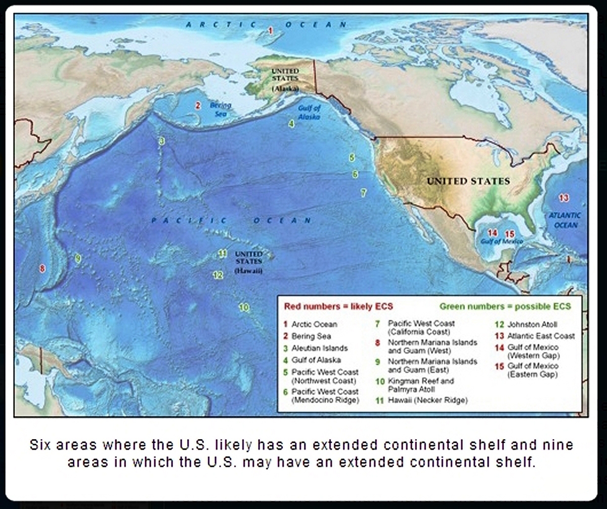
What do California, Oregon, Washington, North Carolina and Alaska offshore oil and gas exploration have in common besides BOEM? A newly defined (extended OCS) ECS, or Extended Continental Shelf.
I recently perused USGS and EIA maps of resources from 2008-2009, before the Monterey Shale became a dream scoop of inflated hype, along with shale development portfolios nationally by bullish investment and debt.
In 2008 a United States Geological Survey estimated that areas north of the Arctic Circle have 90 billion barrels of undiscovered, technically recoverable oil and 44 billion barrels of natural gas liquids in 25 geologically defined areas thought to have potential for petroleum. This represented 13% of the expected undiscovered oil in the world. Of the estimated totals, more than half of those undiscovered oil resources were estimated to occur in just three geologic provinces Arctic Alaska, the Amerasia Basin, and the East Greenland Rift Basins.
There are methods for estimating 'undiscovered resources', always have been. The methods are just more expensive and technologically accurate today.
Also, more than 70% of that mean undiscovered oil resource was estimated to occur in five provinces: Arctic Alaska, Amerasia Basin, East Greenland Rift Basins, East Barents Basins, and West Greenland-East Canada.
It was, at the time though, further estimated that approximately 84% of the oil and gas would occur offshore. Economic factors such as the effects of permanent sea ice or oceanic water depth were not considered in the overall assessment of undiscovered technically recoverable oil and gas resources. Nor the extreme effects of changing global climate and weather patterns.
Going Further And Deeper For Oil And Gas: Expanding the OCS
How will drilling in new OCS expanded territories be regulated?
BAT – Best Available Transparency
Cook's Inlet is the only exception to US EPA Marine Effluent Discharge Regulations covering diesel fuels. Even though “there is no ocean discharge of diesel oil (see CFR §435.43 and §435.45). Diesel oil refers to the grade of distillate fuel oil, as specified in ASTM D975-91.”
(1) The Coastal Subcategory bans the discharge of the following waste sources and thus there are no related analytical or test methods: non-aqueous drilling fluids (NAFs) and produced sand (see CFR §435.42, §435.43, §435.44, §435.45).
(2) The Coastal Subcategory bans the discharge of drill cuttings associated with non-aqueous drilling fluids unless there are technical limitations (see §435.43 and §435.45). Appendix 1 of 40 CFR Part 435 Subpart D provides the method for permit writers to determine when operators qualify for an exemption from this discharge prohibition.
EPA Region 10
A lot of this is based on economics factors of cost that favor the bottom line and BAT, Best Available Technologies. But there aren't any. Disposal in the Arctic Region is a real problem. Pipelines to shore won't last, and the ice flows make shipping it to shore for disposal impracticable! New well and platform designs that use the same borehole for production and disposal are in the processes of design and testing. This looks really scary in terms of potential for disaster.
Closer To Home - Offshore Of Northern California
“On 17 May 2009, the Kongsberg EM302 multibeam echo sounder on board the U.S. National Oceanic and Atmospheric Administration’s (NOAA) Okeanos Explorer was collecting bathymetry and water column acoustic data offshore of northern California when it suddenly imaged a previously undiscovered 1400-meter- high plume (Figure 1) rising from the seafloor at 40º32.13’N, 124º47.01’W. The ship was mapping in water depths of approximately 1830 meters and heading east up the northern California continental margin 20 kilometers north of the Gorda escarpment.”
“The continental shelf in this area is known to have subsurface and water column thermogenic and methane gas, although no plumes from this area previously have been reported from deeper than the continental shelf. The plume, which rises vertically 1000 meters before being deflected to the north, was recorded for approximately 5 minutes before it disappeared from the data.” The 15 year research and mapping has recently concluded.
http://onlinelibrary.wiley.com/doi/10.1029/2009EO320003/pdf
The plume was mapped again by the multibeam echo sounder on board the Okeanos Explorer on 3 June 2009 during daylight. The ship stayed over the plume for 2.5 hours.
“It is believed that this plume is not a hydrothermal vent and is not associated with the Mendocino transform fault. It appears from the characteristics of the feature that it is a plume of methane gas bubbles coated with a methane hydrate.”
http://oceanexplorer.noaa.gov/explorations/14mendocino/welcome.html#okeanos
James V. Gardner, Center for Coastal and Ocean Mapping, University of New Hampshire (UNH), Durham; Mashkoor Malik, Office of Ocean Exploration, U.S. National Oceanic and Atmospheric Administration (NOAA), UNH, Durham; and Sharon Walker, Pacific Marine Environmental Laboratory, NOAA, Seattle, Wash.
I think about this 1400 meter plume of Methane from the seafloor, which looks like a vented amphitheater of a once active volcano, discovered offshore of northern California. Methane hydrates, ice crystals... that possibly help to keep our North Coast waters and the Pacific NW ocean upwelling waters quite cool. It's a 1400 meter plume of Methane rising from 1800 meters below the surface nearly vertically through the water column, deflects northward at about 800 meters below the surface, and disappears about 400 meters below the surface.
From September 23 - October 12, 2014, NOAA and University of New Hampshire scientists were aboard the Woods Hole Oceanographic Institution-operated Research Vessel Atlantis and conducted a 16-day mapping expedition to the Mendocino Ridge off the coast of northern California. The scientists sailed from Astoria, Oregon, and ended in San Francisco, California. Seafloor bathymetry and acoustic backscatter data and high-resolution sub-bottom profiles were continuously collected during the expedition.
“The new data is expected to improve seafloor maps of the area and contribute to the efforts of the U.S. Extended Continental Shelf Project (ECS), a multi-agency project to delineate the outer limits of the U.S. continental shelf.”
http://oceanexplorer.noaa.gov/explorations/14mendocino/welcome.html#okeanos
“The data collected by NOAA and University of New Hampshire scientists aboard R/V Atlantis during will improve our understanding of the unique geology of the Mendocino Ridge as well as contribute to national continental shelf mapping priorities. All collected data will be available in NOAA’s public data archives within 30 days of the conclusion of the cruise and will be accessible via the OER Digital Atlas
http://www.ncddc.noaa.gov/website/google_maps/OE/mapsOE.htm
and NOAA’s National Geophysical Data Center.
http://www.ngdc.noaa.gov/ngdc.html
The U.S. Extended Continental Shelf Task Force directs and coordinates the ECS Project, an effort to delineate the U.S. continental shelf beyond 200 nautical miles.
http://continentalshelf.gov/
Why this expansion of The US Exclusive Economic Zone?
It's a seafloor land grab for oil and gas.
Which leads me to comment on a story circulating wide and far in the US media.
Hardscape Habitat: Bad Math In The Jonah Goldberg Commentary!
The story that is circulating far and wide in the US media goes like this: “Turns Out Oil Rigs Are Actually Beneficial To Undersea Creatures “1,000 Percent More Fish And Other Sea Life Than Natural Habitats” published 10222014.
The timing is most interesting. Measures to Ban Fracking have made it to the ballot in four California Counties, and will be voted on this November - one of which is Santa Barbara where offshore rigs and ocean fracking have been a hot topic all year.
And the plan at BOEM is to extend the OCS thereby opening up new lease areas off the coasts of North Carolina, and other Atlantic Seaboard States, and if possible politically, Northern California, Oregon, and Washington. It's got to sound good – nationwide.
New York
http://nypost.com/2014/10/21/of-irony-and-endangered-species/
“In a 15-year study, researchers found that the ecosystems that build up around artificial rigs host 1,000 percent more fish and other sea life than natural habitats such as reefs and estuaries. The California rigs outstripped even famously rich ecosystems such as the coral reefs of French Polynesia.”
Arizona
http://tucson.com/ap/commentary/goldberg-the-good-news-about-offshore-oil-rigs/article_06d0ac15-39c3-52fb-b633-3f86a75b8ae3.html
And Ohio;
http://www.dispatch.com/content/stories/editorials/2014/10/22/turns-out-oil-rigs-are-actually-beneficial-to-undersea-creatures.html
What was actually stated by the authors of the study is that:
“about an order of magnitude higher than fish communities from other marine ecosystems”
"We find that fish production rates around individual oil rigs, scaled per unit of seafloor, tend to be around 10 times higher than comparable estimates in other highly productive marine habitats such as reefs and estuaries," says Jeremy Claisse of Occidental College in Los Angeles, who led the study.
http://www.pnas.org/content/early/2014/10/08/1411477111.abstract
Edited by David W. Schindler, University of Alberta, Edmonton, Canada, and approved September 22, 2014 (received for review June 20, 2014)
“Secondary production is the formation of new animal biomass from growth for all individuals in a given area during some period of time. It can be a powerful tool for evaluating ecosystem function because it incorporates multiple characteristics of a population or community of organisms such as density, body size, growth, and survivorship into a single metric. Here, we find that fish communities living on the complex hardscape habitat created throughout the water column by the structure of oil and gas platforms off California have the highest secondary production per unit area of seafloor of any marine ecosystem for which similar estimates exist.”
“Secondary (i.e., heterotrophic or animal) production is a main pathway of energy flow through an ecosystem as it makes energy available to consumers, including humans. Its estimation can play a valuable role in the examination of linkages between ecosystem functions and services. We found that oil and gas platforms off the coast of California have the highest secondary fish production per unit area of seafloor of any marine habitat that has been studied, about an order of magnitude higher than fish communities from other marine ecosystems.”
“Most previous estimates have come from estuarine environments, generally regarded as one of the most productive ecosystems globally. High rates of fish production on these platforms ultimately result from high levels of recruitment and the subsequent growth of primarily rockfish (genus Sebastes) larvae and pelagic juveniles to the substantial amount of complex hardscape habitat created by the platform structure distributed throughout the water column.”
“The platforms have a high ratio of structural surface area to seafloor surface area, resulting in large amounts of habitat for juvenile and adult demersal fishes over a relatively small footprint of seafloor. Understanding the biological implications of these structures will inform policy related to the decommissioning of existing (e.g., oil and gas platforms) and implementation of emerging (e.g., wind, marine hydrokinetic) energy technologies.”
JG changed the metrics of “multiple characteristics of a population or community of organisms such as density, body size, growth, and survivorship stated as “an order of magnitude” and “10 times higher” to “1000 per cent more fish and other sea life.” The original scaled metric was for 'Secondary production' - “the formation of new animal biomass from growth for all individuals in a given area over some period of time.”
Supplemental info
http://www.pnas.org/content/suppl/2014/10/08/1411477111.DCSupplemental
http://www.pnas.org/cgi/content/short/1411477111
Now there are those that think the sport fishing is just great around offshore rigs in the GOM. Perhaps after the oil washes ashore, and over reefs, the only vertical structures around might be the rigs offshore.
The seafloor skyscraper fish story was published in the New Scientist, 9 days before the Jonah Goldberg Commentary: Fish Love Skyscraper-Style Living Under Oil Platforms by Andy Coghlan October 13, 2014
http://www.newscientist.com/article/dn26375-fish-love-skyscraperstyle-living-under-oil-platforms.html#.VEyDMWPLJgg
“Think twice before condemning all oil and gas rigs as threats to nature. A submarine study has found that fish are 27 times more productive under rigs than on reefs off the coast of California. And it's not just a West Coast thing. When the Californian rigs are compared with natural marine habitats all around the world, they still boast about 10 times more fish.”
NOTE: The report states: “that fish were dramatically more abundant around the rigs, which ranged in productivity from 105 to 887 grams of fish per square meter of seafloor per year. That is 27 times the comparable productivity range of the deep rocky reefs they surveyed.”
That is the rig count of biomass, vertically speaking. But what of the Benthos?
Of course the depositional field around offshore rigs of the plume of drill cuttings, drilling fluids, produced water, sand proppants etc., all known as effluent discharge, ranges from directly beneath the rig to several thousand meters away transported by currents. The amounts deposited are enormous and by weight alone can suffocate the Benthos. Toxicity and bioaccumulation are concerns, as are impacts in the water column to fish by clogging or cutting the gill membranes (which is not listed as a toxicological effect, and neither is suffocating the Benthos).
For the Benthos, the period of deposition and contamination of their environment is one of weeks or months by the drilling muds and drilling fluids, clays and cuttings; acid baths, completion fluids, biocides; flowback; and then 7 or 8 years of deposition by production wastewater discharge, totalling some 13.5 million gallons, for Platform Irene off the Santa Barbara Coast as illustrated in the results of recent far-field dispersion modeling.
Offshore boreholes, through submerged geologic strata, where pressures create high heat conditions, combined with the mechanics of the rig systems currently in place, require that drilling fluids, drilling muds, sand, and cuttings, be discharged in plumes through the marine water column in which heavy metal constituents and clays, are deposited on top of the sea floor sedimentary layers of life, or hauled to shore for disposal.
EPA Toxicity Tests And The Median Lethal Concentration Of Drilling Fluids
40% of Benthic organisms killed every 4 days? In the tests and methods protocol by the EPA, this is the acceptable kill ratio after 96 hours for test organisms in solutions of drilling fluids. It is actually 50% maximum and known then as (median lethal concentration, LC50). Sand and proppants are tested for 10 days. But in the real environment, drilling goes on for weeks or months, and so do the discharges. Then the discharges shift in chemical composition from cuttings and drilling muds, to well completion, flowback, and produced water. And there are acid flushes at various times.
“Offshore drilling may take as little as 15 days or as long as 12 months, of round-the-clock, seven-days-per-week operation to drill a single well depending on the complexity of the project.”
http://www.diamondoffshore.com/offshore-drilling-basics
Non-Toxic Doesn't Mean Non-Lethal
The test organisms live in a carefully controlled environment to absolutely minimize stress of any kind on their little bodies before introduction to the 'test drilling solutions'. And it's a one time deal, 50% - 90% die, depending on the test, and the rest are tossed. It is figured that around 9% of healthy test organisms die naturally without any input.
“The presence of sediment layers at the benthic zone provides many nutrients and adds greatly to species richness. Because the benthic zone has such a range of depths, many kinds of organisms may live there. Crustaceans, sponges, bivalves, snails, sea stars, polychaetes, fish, and many others can inhabit the zone (Konhauser 2007).”
http://microbewiki.kenyon.edu/index.php/Benthic_Zone
Russia, Europe, Norway, have much more detailed research from the offshore fields than the US, and Norway much tighter restrictions, but the US has the most robust drilling guidelines and Oil and Gas Laws.
Predatory Language In The Regulatory Framework Of US Guidelines And Standards
No cumulative effects assessment of prolonged operations in the field (offshore) has been accomplished. Petri dish protractors yield bioassay data on individual fluid and solids components per the amounts or concentrations of patented slurries. Office hours limit test scenarios and kill ratios to 4 or 10 days, when actual timescales of field deposition at any US offshore rig is much longer.
After 6 months of researching offshore drilling fluids, drill cuttings, effluent discharge toxicity data and EPA criteria, all I can say is that “Non-Toxic Doesn't Mean Non-Lethal.”
Three Per Cent – The Partial Test Economics Of Killed Organisms
Parameters of acceptable numbers of killed organisms yield methods to determine specific levels of toxicity in a 'partial test' if conducted according to EPA protocol. These test results can then be used to demonstrate that a test material passes the toxicity test.
“Sixty test organisms are used for each test concentration. Find the number of test organisms killed in the control (zero percent SPP) concentration in the column labeled X 0 of Table 3-3. If the number of organisms in the control (zero percent SPP) exceeds the table values, then the test is unacceptable and must be repeated. If the number of organisms killed in the 3% test concentration is less than or equal to corresponding number in the column labeled X 1 then the test material passes the partial toxicity test. Otherwise the test material fails the toxicity test.”
A worst case scenario is that only 35 out of sixty survive, and the drilling fluid still passes the test for discharge into ocean waters.
Analytic Methods for the Oil and Gas Extraction Point Source Category
U.S. Environmental Protection Agency
Engineering and Analysis Division
Office of Water
1200 Pennsylvania Avenue, NW
Washington, D.C. 20460
December 2011
EPA-821-R-11-004
Now Back To The Global Offshore Resource Land Grab (GORLG)
Of course it's all 'submerged lands'.
The U.S. Extended Continental Shelf Task Force is an interagency body, chaired by the Department of State with co-vice chairs from the National Oceanic and Atmospheric Administration and the Department of the Interior. Ten additional agencies participate in the Task Force: the U.S. Geological Survey, the Executive Office of the President, the Joint Chiefs of Staff, the U.S. Navy, the U.S. Coast Guard, the Department of Energy, the National Science Foundation, the Environmental Protection Agency, BOEMRE, and the Arctic Research Commission.
http://continentalshelf.gov/about.html
Under customary international law, (the Convention on the Law of the Sea), every country automatically has a continental shelf out to 200 nautical miles from its shore (or out to a maritime boundary with another country). In some cases, a country can have a continental shelf beyond 200 nautical miles if it meets certain criteria. Typically, the portion of continental shelf beyond 200 nautical miles is called the "extended continental shelf” or simply the ECS.
This legal definition of the continental shelf is not the same as what a geologist would call a continental shelf. The rules for defining the ECS are based in international law, specifically Article 76 in the Convention on the Law of the Sea.
A country can use one of two formulas in any combination to determine the edge of its ECS. The Convention also says there are two constraint lines that those two formulas cannot extend past. A country can use any combination of those constraint lines to maximize its shelf.
A country may use the sediment thickness formula or the bathymetric formula to define the outer limits of it's continental shelf. A country may use either constraint line to define the outer limits of its continental shelf: either 350 nautical miles seaward of the baseline, or 100 nautical miles seaward of the 2,500-meter depth contour (isobath).
http://continentalshelf.gov/missions/10arctic/background/shelf.html
Article 76 may be found here:
http://www.un.org/Depts/los/convention_agreements/texts/unclos/closindx.htm
What happens when floating refineries and giant FLNG ships (as now operate in Australia and Indonesian ocean waters) and deep sea wellheads or floating drilling rigs begin to operate in what was once International Waters? There are a myriad of subjects of concern:
1) Deep Water Relief From Royalties (Corporate Welfare)
2) Environmental Law
3) Multiple wells from a single offshore pad/rig - a scenario of continual non-linear repeated deposition of effluent discharges
4) Pipelines and Hurricanes - huge impacts on the seafloor
5) Taxes
6) Worker Safety Laws
Acidization Of Marine Carbonates
Acidizing with combinations of HCI and mostly HF Acid is the preferred well stimulation treatment for carbonates. Marine carbonates are important hydrocarbon exploration plays and produced 50% of the global total oil production in 2004). Oil production in the Middle East accounts for 30% of the global total production (BP, 2011) and 83% of the oil is from marine carbonates.
Oil, gas and condensate reserves in marine carbonates account for 44.0%, 38.1% and 59.0% of the total oil, gas and condensate reserves respectively. In terms of oil equivalent, reserves in marine carbonates make up 42.1% of the World total reserves. (2010)
California Tight Gas Sands, Hydraulic Fracture Stimulation, Offshore Oil and Gas Basins
What is the significance of access to Northern California's Eel River Basin offshore Methane Hydrates? 90% of the Eel River Natural Gas Basin is offshore, the pay zones are thin onshore.
Methane (Natural Gas) Hydrates in offshore subduction zone sediments hold the world's largest reserves of Natural Gas. More than all combined known global shale gas reserves. Not all coastlines share this geologic feature. The Eel River Basin (offshore) is important enough to be shown on the Global Inventory of Methane Deposits.
http://geology.com/articles/methane-hydrates/
Just for the historical record, 60km off the coast at Crescent City, July 1996
Offshore Natural Gas Hydrates In Marine Sediments, Sandstones
“This informal report was prepared from the shipboard files by the scientists who participated in the cruise. Preliminary Report No. 67, First Printing 1996. Electronic Distribution copies of this publication may be obtained from the ODP Publications Home Page:”
http://www-odp.tamu.edu/publications
OCEAN DRILLING PROGRAM CALIFORNIA MARGIN
http://www-odp.tamu.edu/publications/prelim/167_prel/167prel.txt
LEG 167 PRELIMINARY REPORT: Leg 167 drilled 13 sites along the climatically sensitive California Margin. Site 1019 (Proposed Site CA-1D)
Site 1019 is located about 60 km west of Crescent City, California, in the Eel River Basin at a water depth of 983 mbsl (Fig. 1). It is the nearshore site of the Gorda Transect. The primary drilling objective was to sample a high-resolution Pleistocene sediment section as part of the coastal transect from 30° to 40° N and as part of the Gorda Transect across the California Current at 40° N. One of the important objectives at this site was to study the formation of the bottom-simulating reflector (BSR) and to sample gas hydrates. A high-resolution pore-water sampling program was carried out to detect evidence of gas hydrate formation. A logging program was added to measure the extent of gas hydrate formation in situ (permeability).
The significance of the discovery of the Methane Plume offshore of Northern California may be vital to the nourishment in the upwelling, the ambient temperature in the water column, and the plume may be a tectonic pressure relief mechanism.
Extend and Expand the Outer Continental Shelf Moratoria on Oil and Gas Development!
Extend The Cordell Banks Farallones National Monument Marine Sanctuary Boundaries!
The ECS Project and what becomes of it's research requires thoughtful consideration by all.
Thinking about it all now, the ECS Project spanned 15 years and was completed this Oct 2014. Going back 15 years takes one to 1999, and the passage of the Marine Life Protection Act. Fast forwarding to 2006-2011, the MLPA Initiative Blue Ribbon Task Force was eventually chaired by the CEO of the Western States Petroleum Association (WSPA) - Catherine Reheis-Boyd.
Oh the irony:
“Stop Fooling California Exposes Oil Lobbyist Conflict Of Interest” by Dan Bacher
Published Wednesday Jul 23rd, 2014
https://www.indybay.org/newsitems/2014/07/23/18759074.php
It's Time To Ban Fracking
Tomas DiFiore
By invoking the 'Copyright Disclaimer' Under Section 107 of the Copyright Act 1976, allowance is made for "fair use" for purposes such as criticism, comment, news reporting, teaching, scholarship, and research. Fair use is a use permitted by copyright statute that might otherwise be infringing. Non-profit, educational or personal use tips the balance in favor of fair use."
§ 107. Limitations on exclusive rights- Fair use: Notwithstanding the provisions of sections 106 and 106A, the fair use of a copyrighted work, including such use by reproduction in copies or phonorecords or by any other means specified by that section, for purposes such as criticism, comment, news reporting, teaching (including multiple copies for classroom use), scholarship, or research, is not an infringement of copyright. In determining whether the use made of a work in any particular case is a fair use the factors to be considered shall include (1) the purpose and character of the use, including whether such use is of a commercial nature or is for nonprofit educational purposes; (2) the nature of the copyrighted work; (3) the amount and substantiality of the portion used in relation to the copyrighted work as a whole; and (4) the effect of the use upon the potential market for or value of the copyrighted work.
If you or anyone wish to use copyrighted material from this article for purposes of your own that go beyond 'fair use', you must obtain permission from the copyright owner.
STEAM INJECTION IS LITERALLY GLOBAL WARMING
constant comments, and informative research links;
http://banslickwaterfracking.blogspot.com/
Tomas DiFiore
Add Your Comments
We are 100% volunteer and depend on your participation to sustain our efforts!
Donate

$95.00 donated
in the past month
Get Involved
If you'd like to help with maintaining or developing the website, contact us.
Publish
Publish your stories and upcoming events on Indybay.
Topics
More
Search Indybay's Archives
Advanced Search
►
▼
IMC Network