

This Land is Your Land, This Land is My Land
Here is a link to the article originally published on Sacramento Press
http://sacramentopress.com/headline/44690/PART_1_This_Land_is_Your_Land_This_Land_is_My_Land_Looking_Back_at_50_Years_of_the_Capitol_Area_Pla
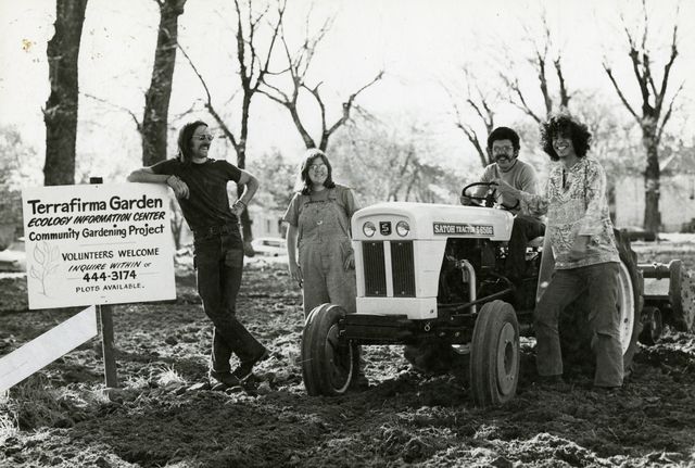
Image by: Courtesy of Center for Sacramento History, Eugene Hepting Collection, 1995/026/0681
Fifty years ago last month, the California State Legislature adopted the first version of the Capitol Area Plan (CAP). Revised in 1977 and again in 1997, this document’s incarnations have ordered the acquisition and arrangement of the state’s central city properties in the Capitol Area, a state-defined zone encompassing a sizeable swath of downtown.
The story of Sacramento’s downtown development is convoluted, but the CAP is a key thread throughout that story. To mark its golden anniversary, this retrospective focuses on how the plan affected a specific block: the one enclosed by 14th, 15th, P and Q streets. Once the site of the Ron Mandella and Southside Community Gardens, identified as block 286 in the original plan and known as site 13 during its most notorious period, its contentious history is as misunderstood as the CAP itself.
The first CAP’s local context was the staggering number of Capitol-centric studies and proposals floated throughout the 1940s and 1950s. Like most U.S. urban cores during the 1950s, downtown Sacramento had a tax base seeping out to the suburbs and a residential population that didn’t match televised examples of desirable neighborhoods. Even though the full story of U.S. postwar development is much more complex, for the purpose of putting the CAP in national context, the most important part to know is that massive federal funding incentivized local projects claiming to solve so-called blight. As historian Rebecca Solnit put it, “Blight was the magical word of the era of urban renewal, a word whose invocation justified the destruction of housing, communities and neighborhoods in many American cities.” In the subsidy-soaked wake of the 1945 California Redevelopment Act and the 1949 Federal Housing Act, the Sacramento City Council declared a sixty-block slice of downtown blighted in 1950.
The blight designation galvanized the West End redevelopment, a city-spearheaded project that displaced of thousands of people. The Public Administration Service’s summary of the project, published the year demolition began, gave the principal reason for the human displacement and physical destruction: “the improvements wrought by downtown redevelopment will make the entrance from the West one befitting a city that has a major place among the capital cities of the nation.” (The above photo of Taylor’s Drugstore, taken on the first day of demolishment, is one example of the community’s reaction to the improvements).
The West End was only one facet of the city’s makeover, though, because the state had a stake in downtown’s image too. In 1959 the State Legislature formed a commission charged with producing a master plan for developing “future State buildings in the Capitol area of the City of Sacramento.” The Commission assembled consultants in July of 1960, and they published the California State Capitol Plan (the CAP’s initial title) on December 12, 1960.
The proposed Beaux-Arts state worker supercampus hewed to the vision of Pat Brown’s grandiose California Master Plan. In order to replace the low-income (and multi-ethnic) neighborhoods bordering Capitol Park with interlocking satellite campuses and superblocks, the CAP recommended that the State buy 42 blighted blocks south and east of the Capitol and demolish the existing buildings. The document candidly laid out the state’s intent to leverage both the federal subsidies and the political support for redevelopment, not to improve slum conditions, but to install a postcard-perfect setting for Capitol Park.
The CAP went beyond merely organizing or consolidating existing state property. Instead, it mandated total visual consistency in the Capitol’s environs: “The principal purpose of the plan is to give California a noble and monumental seat of government. This aim cannot be accomplished unless Sacramento becomes a great capital city. Therefore, the plan looks beyond the confines of the Capitol complex, to its approaches and to the surrounding areas.” Within the blighted area, the CAP demarcated and named a second area, in effect doubly damning those neighborhoods. Targeted by both city and state for architectural sanitization, “Capitol Area” residents were left with little recourse.
The CAP recommended the State Legislature act quickly: “Because almost all of the properties now are occupied by relatively low value improvements, the land should be purchased before new development greatly increases its cost. Properties not needed for building sites, parks and plazas by 1980 are to be used for parking lots on an interim basis.” Meaning, the plan’s authors fully expected some blocks to remain vacant for up to twenty years.
Despite its inclusion in the 1950 blight decree, block 286 was still intact ten years later, comprising mostly homes built between 1880 and 1920. The 1960 CAP slated them for replacement with a cafeteria and three office buildings.
Two years after the Plan’s adoption, however, a Capitol Building and Planning Commission’s report showed that land acquisition was not proceeding as planned, and called for more aggressive methods. Under the heading “Emergency Purchases,” the report outlined the barriers to state purchase and the solution:
“Since the adoption of the Capitol plan there have been several proposals by private property owners to place expensive improvements on land which is included in the plan…Several persons have experienced difficulty in selling because of a feeling of uncertainty on the part of potential buyers once they know the property is included in the Capitol plan. The recommended solution to this problem is outright acquisition by the State through a revolving fund established for this purpose. This should be accomplished at the earliest possible date.”
The minutes of the State Public Works Board’s meetings between 1964 and 1967 prove the Board authorized and deployed eminent domain in order to seize the properties on block 286 (a simple definition of eminent domain is when the government compels the sale of private property, in order to build projects ostensibly for public benefit, such as a freeway). With the threat of eminent domain looming, most property owners sold their homes and left. A few property owners remained defiant and held on to their homes until a court issued condemnation orders in 1970, giving the parcels to the state. (The homes pictured above were among the seized properties, and were on a section of the block where the original Southside Community Garden [OSCG] later overlapped with the Ron Mandella Community Garden [RMCG]. The Center for Sacramento History has photographs of nearly every home on the block’s Q street side that the RMCG occupied).
After Reagan became governor, he cut the funding for the building phase of the CAP and leased state office space from the private sector. Both the 1977 and 1997 CAPs claim the leasing program caused the geographic dispersion of state offices. This is not true, since legislators had been complaining about scattered state facilities for decades prior and the 1960 CAP failed to make significant progress on that front. But even if the leasing program had caused state building sprawl, there’s a more salient point: several parcels on block 286 were acquired, some by eminent domain, after Reagan took office in 1967. If his administration didn’t intend to fund development, why did they continue to seize and demolish homes? Neither the 1977 nor 1997 CAPs’ summaries of the 1960 CAP mention eminent domain at all. Nor do they explain why seizure and demolition of residences continued for years after the 1960 CAP’s goals were abandoned and defunded.
Roughly around the same time, a loosely affiliated mix of local residents, college students, and state workers began cultivating the freshly bulldozed block. Various sources trace the earliest garden activity as beginning anywhere from the mid-1960s to 1975. The RMCG’s archived internal documents cite 1971. The Sacramento Bee has published a few different start dates in different articles. The EPA’s Brownfields website says the garden began in the mid-1960s, and the Fremont Community Garden’s webpage says the late 1960s. Judge Lloyd Connelly, who assisted the RMCG when he was on the Sacramento City Council and again during his California Assembly tenure, told me he could not remember when the garden started. The sparse documentation of this chapter of the gardens’ story underscores the importance of rigorous local history.
At the very least, the above photo of unidentified gardeners is dated circa 1973. It seems likely the first lease was brokered between the long-since-defunct Ecology Action Center and the Department of General Services (DGS) in 1974, formalizing the “Terrafirma Garden.” (I was unable to verify whether the OSCG splintered off from Terrafirma, or if it was always separately managed). In an arrangement typical of most 1970s-era community gardens that were started in response to the failure of urban renewal, the lease with DGS was short-term, renewable, and $1 per year.
Both community gardens had been cultivated for at least four years when the 1977 CAP was published, after DGS recommended a complete review in 1973 and Jerry Brown ordered an update in 1975. The revised CAP still focused on state building development, but with the younger Brown’s small-is-beautiful spin. Former State Architect Barry Wasserman, one of the 1977 CAP’s primary authors, described the plan as a “demonstration project” that showed how to “rebuild a part of the city that needed rebuilding in a compassionate, holistic way.”
Despite several paragraphs rhapsodizing about open space, including the possibility that “sites may offer community gardening with plots available to residents and members of the community who want to grow food and flowers,” the 1977 map divvied block 286 into three-quarters housing and one-quarter parking. Though Brown later founded a nonprofit that touted community gardening, during the time he was overhauling his father’s CAP (and living one block away from the gardens), he did not take the opportunity to permanently dedicate the block to community gardening.
I asked Wasserman how the State Architect’s office perceived the Terrafirma Garden, since it preceded the CAP’s revision. He described the garden as a “purely temporary example of what could be” (he also described the planned office buildings as “demonstration buildings,” and noted a separate “demonstration garden” was built nearby, which closed after a few years). When I asked why block 286 was designated as housing, pointing out that the plan did call for community gardens, he replied that housing “was a way to use the land in a way that most supported the principles of the plan.”
Yet the housing designation can only be seen as a subjective decision, since using the block as garden space surely supported the plan’s principles of conservation, diversity and open space (the design of the latter, the plan admonished, “should always be done with people in mind”). Furthermore, disregarding the community-developed site use in favor of state-planned parking and housing—even as a genuinely well-intentioned attempt to restore the block to its pre-1960 CAP use—violated the plan’s principle of community development.
The redesignation notwithstanding, the gardens were still thriving in 1978 when two events transferred the lease to new parties. Ron Mandella, a state worker and founding garden member (pictured here in the Center for Sacramento History image archives), was killed while defending a neighbor from an attacker, and became the namesake for the newly-formed non-profit that took over the garden’s management from the Ecology Action Center.
1978 was also the year the State Legislature created the city-state joint powers agency Capitol Area Development Authority (CADA), to take over implementation of the CAP’s residential projects from DGS. DGS was, by all accounts, as inept at property management as it was at urban design (as Judge Connelly put it, “General Services just dumps all over the city of Sacramento with their architectural standards and projects”). Wasserman summed up the new agency’s dual purpose as “designed to get the state out of the housing business and form a partnership between the state and the city to make the city whole again.” CADA’s primary role has always been to realize the CAP’s housing and retail goals.
From its inception, CADA sought to build over the gardens. When UC Davis professor Mark Francis published his 1987 “Landscape Journal” article comparing how community members and CADA officials perceived the gardens and Fremont Park, many stabs at development had already been made: “The permanency of the two gardens has remained a critical issue for the gardeners…the gardens were referred to by one official as a ‘loose bar of soap,’ since control of the site has been an ongoing issue for the development authority.” CADA succeeded in paving over the OSCG in 1987 for a parking lot, but community organizing efforts thwarted the agency’s continual attempts throughout the 1980s and 1990s to destroy the RMCG. (These attempts were not always for the sake of housing either—Prof. Francis’s article stated, “According to CADA, the site is not a prime location for a new state office building within the next five years, but could be developed for parking or other office-related uses”).
By the time the CAP was revised again in 1997, the RMCG was the oldest and largest local community garden. It had grown from being a community-developed institution to a community in its own right. In addition to long-term partnerships with dozens of community groups, the garden benefited the whole city as downtown’s second-highest oxygen producer. But even while meeting many of the 1997 CAP’s objectives, block 286 was classified as “vacant and underutilized,” and the RMCG was indirectly referred to as an “interim use.” The 1997 CAP slated the block for low density housing (which the plan defined as “less than 35 units per net acre”) and described the site as an “opportunity…to facilitate ownership housing.” The Fremont Mews apartment complex has 119 units on 2.2 acres, and none of them have ever been for sale.
When CADA issued a Request for Proposals to private developers in 2000, the subsequent fight between RMCG advocates and CADA ended in 2004 with the RMCG’s destruction and two new gardens, one built as part of Fremont Mews and one built near Southside Park. A full account of the final protracted battle—especially regarding the lawsuits, the soil remediation issue, and the garden advocates’ organizing strategies—is still lacking, but the contested details of those years are not covered here. Instead, two of CADA’s tactics during this period are reconsidered in light of the evidence presented thus far: one, their presentation of the block’s 1997 housing designation as historically consistent and absolutely immutable, and two, their slippery use of the term “public.”Not long after issuing the RFP, CADA disseminated a brochure entitled “Striking a Balance: CADA and the Mandella Gardens,” which stated:
“For a quarter century the State of California has owned Site 13…the land has been designated on the Capitol Area land use plan for residential use. CADA is proposing that the site be developed consistent with this long-established Plan…urban open space will be retained and housing and potential mixed use development can occur just as always intended.”
The CAP is perfectly capable of shifting buildings and uses from one site to another—and it has done so countless times. The 1997 introduction explicitly stated, “variances in these designations have continuously occurred throughout the plan implementation.” And the planned uses for block 286 have morphed almost as often as the gardens were threatened. The 1960 CAP created the true blight in the first place by razing the existing housing in order to give state workers a view of Fremont Park on their lunch break. Various configurations of parking, office buildings, ownership housing, rental housing, and retail (remember the grocery store proposal?) have been revised multiple times over the past fifty years. In Traci Sinclair’s 2000 Sacramento News & Review article about the RMCG, CADA Development Director Tom Kigar stated, “This site has always been seen as a residential site.” Besides being ironic, since the block was obviously seen as residential before the state destroyed the homes, this statement is also not true, as evidenced by five decades of assorted proposed uses.
The frequent redesignations could be seen as evidence of the CAP’s agility in meeting changing conditions, and indeed, the 1977 and 1997 CAPs boast endlessly about their flexibility. But all that shifting also shows that nothing prohibited the CAP from reclassifying any block—what never shifted was the designation of a mere half-block to permanent garden space. Why? Mark Francis’s article quoted several CADA officials as saying, “‘I do not see state authorities going for permanent gardens; it is a highly valuable piece of property’…‘the moment can still happen when the space will have to be developed’ as a result of rising real estate values.” The white-hot real estate market of the early 2000s was the tipping point for the RMCG’s demise, though at the time, CADA rarely mentioned housing demand, instead emphasizing downtown’s need for affordable housing. Of course no one is opposed to affordable housing, but it is not mutually exclusive with a half-block of affordable food.
CADA also used the term public disingenuously in different ways. In “Striking a Balance,” CADA claimed that it was “as good stewards of public land that we pursue the responsible intended use of this land.” Such a claim omits how the state forced the block to become public land in the first place. And as shown, by definition the agency would not pursue anything but housing development—it does not exist to provide holistic stewardship of all possible public land uses. Moreover, pro-development arguments at the time painted the gardeners as selfishly clinging to taxpayers’ land for the sake of a private playground. Yet CADA’s solution to the problem of a group supposedly claiming exclusive rights to public land, as a “good steward” of that public land, was to sell the site to a private developer so it could be turned into private housing.
“Striking a Balance” also claimed that CADA was requiring “nearly one-half acre of public open space be a component” of the RFP responses, and CADA has made much of the so-called replacement gardens that are now managed by the city. It is true that many people prefer the new gardens, and many more people have no opinion at all. But the Fremont Community Garden and the new Southside Community Garden do not actually replace the RMCG, nor are they truly public. Obviously, the OSCG has never been replaced (except by parking, until the CAP once again shifted its use), and the RMCG’s scores of fruit trees have never been replaced. Most significantly, the RMCG was genuinely public. The fence was unlocked from dawn until dusk seven days a week, there were ample community beds, and there were community events and celebrations regularly.
Neither the Fremont Community Garden nor the new Southside Community Garden is open to the public. Anyone may apply to rent a plot, but that is equivalent to other membership-based private buildings (e.g., fitness centers), not equivalent to public institutions (e.g., libraries). If community gardens are defined as strictly places where plants are grown, than the RMCG has been replaced, square foot for square foot. But if community gardens are defined as by-the-public-for-the-public communities, then the loss is unquantifiable. It can be rebuilt, but not replaced.
The impossibility of replacement raises a difficult question. Each version of the CAP has claimed its flexibility permitted responsiveness to changing conditions. Soon after the Fremont Mews was built, conditions did in fact change: the housing market tanked, and green chic and the recession have raised community gardens’ cachet again. But those particular community gardens on that particular block, those gardens that were on our land and were open to all of us, are gone forever. Was it worth it? It’s a question to keep in mind for all future development projects, especially in view of the CAP’s legacy for downtown.
The 1960 CAP’s authors did not care that its implementation would destroy the community on block 286, because they did not see a community worthy of continued existence—they only saw a chunk of real estate that could be captured, renamed and rebuilt to serve the state’s purposes and the city’s image. The community then challenged the state’s imposition of its will on the neighborhood by salvaging the wreckage of their “monumental seat of government” and developing it into productive green space for everybody.
The 1977 CAP positioned itself as righting the wrongs of the 1960 CAP—although it certainly was not planning to give the original residents their homes back—but both versions never questioned their legitimacy in imposing the state’s vision, however virtuous, without the community’s consent or approval. The 1977 CAP declared, “There must be a ‘Capitol Community’ espirit which grows out of the physical environment,” but refused to acknowledge the community which had organically grown out of, and in spirited response to, the state’s annihilation of the physical environment.
The 1997 CAP continued the legacy of ignoring the community-created development and presenting the state’s capricious whims—allegedly validated by selectively solicited public opinion and urban planning trends—as the only way to develop a vibrant, viable downtown. Shielded by the threadbare histories of Capitol Area redevelopment, CADA obscured the issue of public space to justify state-led development.
Ultimately, the state has always justified the CAP through its self-defined mandate. The 1977 CAP author argued “the plan couldn’t fulfill its mandate without using [block 286] for housing.” CADA repeatedly cited its legislative mandate in their quest to destroy the gardens. The CAP’s legacy is the state’s unwavering indifference to the community it purported to develop, all the while insisting that it was dutifully pursuing the public good. The people constitute the public, however, not the state. For the past fifty years, the people’s mandate has yet to be fulfilled in any version of the CAP.
If you have more information about block 286’s history since 1950, please consider sharing it in the comments or donating it to the Ron Mandella Community Garden Archives at CSUS.
Thanks to Judge Lloyd Connelly, Mark Francis, Tom Kigar, Bill Maynard, Judy Michalowski, Evan Tucker, and Barry Wasserman for their assistance with researching this article.
Special thanks to the staff and volunteers at: The Center for Sacramento History, the State Library, the State Archives, and the Sacramento Special Collections and University Archives at CSUS.
Dedicated to my mom, Nancy Fish (7/13/1950-1/18/2011).
Donate

$110.00 donated
in the past month
Get Involved
If you'd like to help with maintaining or developing the website, contact us.
Publish
Publish your stories and upcoming events on Indybay.