

From the Open-Publishing Calendar
From the Open-Publishing Newswire
Indybay Feature
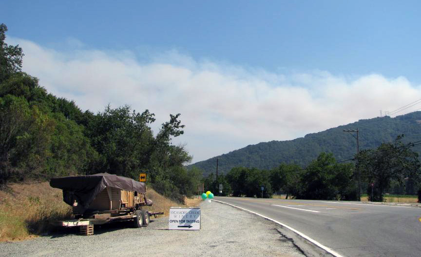
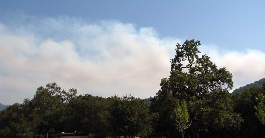
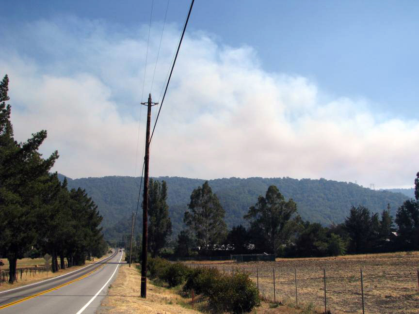
Major Fires Off of Highway 1 In Aptos-Watsonville Consume Homes
At approximately 2:00 p.m. fires started off of Highway 1 between Mar Monte Road and Airport Road. By 6:00 p.m., 1000 acres had already burned and several homes destroyed. It is currently burning out of control and continues to threaten the health and safety of people and animals in the area.
At approximately 2:00 p.m. fires started off of Highway 1 between Mar Monte Road and Airport Road. By 6:00 p.m., 1000 acres had already burned and several homes destroyed. It is currently burning out of control and continues to threaten the health and safety of people and animals in the area.
The fires ignited and took hold rather rapidly, with many people nearby the fires unaware of the danger or what procedures to follow. As an observer of the fire from Freedom Boulevard around 3:00 p.m., I was overwhelmed by the giant flume of smoke that encroached over the city of Freedom and headed towards Watsonville.
Currently, over 2000 people are being forced to evacuate their homes and others are being asked to evacuate, including all areas within the Airport Road, Freedom Blvd and Larkin Valley Road area. Highway 1 is currently closed for a six mile stretch, between Larkin Valley Road and down to Riverside Drive, according to other news reports.


Add Your Comments
Comments
(Hide Comments)
Trabing Fire Update: 1800 hrs - 9 homes confirmed burned,
Trabing Fire Update: 1700 hrs - 500 acres, structures lost, Multiple starts, possible arson, AEU sending Strike team. Large aircraft orders.
Trabing Fire Update:1600 hrs - Residents are being advised to contact the Santa Cruz County Sheriff's Office at 831-471-1121 for information on whether their homes are in an evacuation area.
New Evacuations: Residents along Calabasas Road - Red Cross officials said residents wanting to find up-to-date information on shelter locations should call 831-462-2881.
Large Animals: Santa Cruz County Animal Services has advised livestock owners to take large animals to the Santa Cruz County Fairgrounds for evacuation.
Roads Closures: Highway 1 between Larkin Valley Road and Airport Boulevard, Larkin Valley Road, White Road at Freedom Boulevard
Trabing Fire Photo
Credit: ksbw.com - Link
Trabing Fire:
Name: Trabing Fire
County: Santa Cruz County
Location: North of Watsonville near Hwy 1
Administrative Unit: CAL FIRE Santa Cruz and San Mateo Unit
Status/Notes: 500 acres
Date Started: June 20, 2008 1:58 pm
Last update: June 20, 2008 4:30 pm
Phone Numbers (831) 335-6717 (Trabing Fire Information)
5 Large fires, Multiple columns of smoke building rapidly
Immediate structure threat.
"Fire in the trees and has potential to go "major" per Cal Fire."
Evacuations: Reverse 911 is in use, all of Larkin Valley Rd is being evacuated.
Location: Watsonville airport and highway 1 and Buena vista , Trabing road.
Closures: CHP Ordered to Close Highway 1 in both directions , until further notice , at Airport blvd. in Watsonville.
Resources: BC 1716 - - IC requesting multiple copters and multiple tankers.
Sizeup: Extreme Smoke , Heavy Fuels , Mod ROS
http://calfire.blogspot.com/
For more information:
http://calfire.blogspot.com/2008/06/ca-czu...
What's New - June 2008 Minimize
2nd Annual “Dangers in Paradise” Event
The second annual “Dangers in Paradise” disaster preparedness fair is scheduled for June 21st, 2008. The event will be held at Ramsay Park in Watsonville, from 10:00 AM to 2:00 PM, and is sponsored by the Santa Cruz County CERT Council, Fire Chiefs Association, Public Health and Pacific Gas & Electric. Come learn about disaster preparedness with local CERT (Community Emergency Response Team) members, PG&E, Fire District personnel, Red Cross and other emergency responders. Experience a live earthquake simulation in the Safe-T-Proof “Quake Cottage”, and watch live demos for everything from fire extinguisher use to basic rescue procedures. This event is free, and bound to be both fun and educational for you and your entire family. For more info, click the link to the flyer (below), or email our CERT Coordinator Capt. Mike Conrad at mikec [at] aptosfire.com. You can also learn about CERT at the Seascape CERT website: http://www.seascapecert.org/.
For more information:
http://www.aptosfire.com/
This event couldn't have had better timing.
I went to one of these events last year and it really got me started thinking, planning and connecting with my friends, family and neighbors about making plans for potentially dangerous situations. We all need to take our own personal responsibility seriously and not just expect the government to do everything for us. They had a lot of helpful brochures, samples and information at this event, too.
I went to one of these events last year and it really got me started thinking, planning and connecting with my friends, family and neighbors about making plans for potentially dangerous situations. We all need to take our own personal responsibility seriously and not just expect the government to do everything for us. They had a lot of helpful brochures, samples and information at this event, too.
It's going to be hot and low humidity through Monday, so I hope everyone living near chaparral and trees can watch out. People are going to start using 4th July fireworks in the next couple of weeks, so that is an additional risk.
Trabing Fire Incident Information:
Last Updated: June 21, 2008 7:00 am
Date/Time Started: June 20, 2008 1:58 pm
Administrative Unit: CAL FIRE Santa Cruz and San Mateo Unit
County: Santa Cruz County
Location: North of Watsonville near Hwy 1
Acres Burned: 630 acres
Containment 90% containment - 630 acres. Full containment is expected on 6/21
Evacuations: Evacuations remain in effect for affected fire area
Injuries: 2 minor
Cause: Under Investigation
Cooperating Agencies: CAL FIRE, Santa Cruz County fire departments, CDCR, CHP, Santa Cruz Sherrifs Office, Santa Cruz County OES, Red Cross, Santa Cruz County Animal Services, Santa Cruz County Roads and Caltrans
Total Fire Personnel: 645 (342 CAL FIRE)
Fire crews: 12
Engines: 90 (25 CAL FIRE)
Airtankers: 3 CAL FIRE
Helicopters: 1
Dozers: 4 CAL FIRE
Water tenders: 9
Conditions: The forward progression of the fire has been stopped, but there is heavy mop up in eucalyptus groves. The weather is expected to remain abnormally hot and dry today. Firefighters will continue to improve line and put out hot spots.
Phone Numbers (831) 335-6717 (Trabing Fire Information)
For more information:
http://cdfdata.fire.ca.gov/incidents/incid...
Here is a Senile Article mentioning several fires from Grahm Hill Road to White Road. If anyone heres about the White road lighting fire, please let me know and post whatever you find.
Thanks
Tim Rumford
"SANTA CRUZ - As fire fighters worked to get the Trabing Fire under control today, the weather took a dramatic shift with storm clouds dropping a bit of rain across the county and thunder and lightning rolling through the area.
There were several reports of lightning strikes starting grass fires around the county. A small grass fire across from 680 Graham Hill Road, which firefighters said it was 20 feet by 20 feet, was quickly extinguished.
At 12:50 p.m., there was a report of a larger blaze started by a lightning strike on Larkin Valley and White roads, near where the Trabing Fire burned Friday. Emergency crews were evacuating some people in the area at 1 p.m.
"There are some thunderstorms approaching you guys from off the coast," said Larry Smith, a meteorologist at the National Weather Service in Monterey.
Mid-level moisture moving up from the south, extreme heat in the county and a front to the north are combining to create conditions for thunderstorms around the Monterey Bay, Smith said.
"It's pretty dry underneath the storms so were going to be a little lean on the rain end of it," he said.
The lightning should last through the afternoon, he said.
The weather service had been predicting a high of 94 degrees in Santa Cruz today, but the temperature is dropping with the storm clouds, Smith said.
Temperatures should drop even more Sunday as the front moves past. Highs should be near 79 degrees, Smith said.
"
We are 100% volunteer and depend on your participation to sustain our efforts!
Donate

$140.00 donated
in the past month
Get Involved
If you'd like to help with maintaining or developing the website, contact us.
Publish
Publish your stories and upcoming events on Indybay.
Topics
More
Search Indybay's Archives
Advanced Search
►
▼
IMC Network