

From the Open-Publishing Calendar
From the Open-Publishing Newswire
Indybay Feature
Community People are in danger per USGS Liquefaction Map
Will a poor low income community of color be victimized once again, when clear and imminent danger is avoidable?
Community People are in danger per USGS Liquefaction Map.
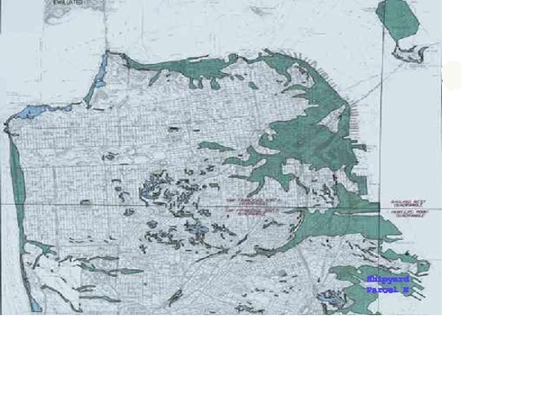
US Geological Survey produced a map of Earthquake Hazard Zones in the Bay Area of known liquefaction danger zones so as to prepare people to be able to protect them selves from incidents like what took place in the Marina District during the Loma Prieta earthquake. So on November 17th 2000 they released the San Francisco Hazard Zone Map, if you look at the map and narrow it down to the Hunters Point Ship Yard you will notice Parcel E is included. The same area identified by Daniel Meer of the EPA as "being too dangerous to be removed" the Parcel E liquefaction danger zone which also had, on August 16th 2000, a major fire incident which burnt for months and endangered the health of the nearby community residents. Well lets recall what took place in the Marina District Loma Prieta quake in 89, another USGS identified liquefaction zone which didn't include underground toxic and radiological hazards.
the Parcel E Toxic Fire of 2000 and the warning that is coming from USGS with their current S.F. Hazard map it seems we have a recipe for disaster and at the very least a disaster waiting to happen, which could cost some of the local residents their life or threaten their health. Why isn't this being addressed by the Regulators, (The EPA, DTSC, Water Resource Board and the Developer, and most importantly the City. At a minimum there should be a warning/evacuation plan in place for the local residents. It cost USGS a tidy sum to produce this map and it was designed to prevent loss of life from major earthquakes and identifying major areas where they expect serious incidents, why is this not being addressed? Is it because it is a low income community of color? Seemingly the Parcel E Landfill Cap will not stand up to Liquefaction and the Navy has predicted a five foot lateral movement in a major quake, and that is why a major study is being undertaken by the Navy with one major option being the removal of the Parcel E Landfill. The community hopes and prays that this takes place before loss of human life from Liquefaction in Parcel E of the Hunters Point Ship Yard.
The implications of a disaster waiting to happen is very clear given what happen in the Marina and that wasn't a toxic radiological fire. It is now more imperative this be addressed with the planed development of the ship yard Parcel E is adjacent to Parcel A which is scheduled for starting development as early as 2005, so you can add workers and the possibility of future residents to the mix of who would be endangered and impacted. You be the judge should this situation be remedied before people are hurt? If the situation is not remedied and community members are injured from liquefaction should those responsible be charged with criminal liability?
For more information:
http://www.mecresources.com
Add Your Comments
Comments
(Hide Comments)
Maurice has noted only stated the obvious facts about the dangers of liquefaction in the central and southern waterfront areas of San Francisco, but he has been and continues to be a warrior for San Francisco Community and Environment.
Only a few thousand yards north of Hunters Point Naval Shipyard , in the area surrounding Islais Creek ,there are more very serious liquefaction dangers that will impact not only our local communities, but will impact all of San Francisco, including the Phelps Sewage Treatment Plant, the Third Street Light Rail Project and all light and heavy industry in this corridor.
Points to note are several:
1. The emergency retrofit /repairs of numerous structural cracks of the Levon Hagoop Nishkian Bridge on Third, between Marin and Amador/Cargo Way (also the path for Light Rail) is placing auxillary concrete pilings that will not reach bedrock, but simply be "sticks in the mud"
Note that bedrock in this area is at depths of 200 to 300 feet.
Thus, in the case of any serious sesmic events, the bridge/rail will be rendered useless and impact not only public transportation north-south, but will impact commerce, which is plenty in this region.
2.More disturbing is that Muni, who caused the PUC sewer line to collapse 3 years ago, is now returning to retrofit the same line, which is nearly 50 years old, and constantly leaks. Retrofits and repairs will implement a coccoon of cement, which is also floating on landfill and 200 feet of ancient marsh sediment. (liquefaction area, serious)
3. Most disturbing, and most corrupt is that the Port of San Francisco will be buidling a new bridge directly on top of this ancient, faulty sewer line, only a few hundred feet east of the levon hagoop nishkian bridgde, to begin within one month. The permits and funding are not yet in place.
What emergency provisions do the Port or Muni have in place should the sewer pipe again collapse? (none I have been told)
4. Finally, and not directly related, yet significant, is that the City of San Francisco, surrounded nearly 80% by water, and with 3 major rivers/creeks, has not intentinally not participated with the Regional Water Quality Control Board just as late as July 2004.
The statistics can be found at this link:
http://www.waterboards.ca.gov/sanfranciscobay/download/bufferreport0704.pdf
There is a lot more to discuss especially related to SF Redevelopment's plans to gentrify these areas without proper EIRs, community participation, and more.
David
For more information:
http://www.islaiscreek.org
Liquefaction: Giving Ground
Liquefaction, a devastating effect of earthquakes, is only now being widely assessed Related Resources
• Liquefaction Links
• Landslides
• Earthquakes
• Bay Area Hazard Maps
From Other Guides
• Civil Engineering and Quakes
It was an undignified thing to happen to a block of flats. Japan is an earthquake-aware country, and when apartment complexes were built in the Kawagishi-cho area in the city of Niigata, they were sturdy reinforced concrete. But after a magnitude 7.5 shock on June 16, 1964, it was not the structures that gave way but the ground beneath them. Hundreds of buildings tilted like ships listing in heavy seas, victims of soil liquefaction. When the time came for repairs, some of the buildings were simply winched back upright without appreciable damage.
Photos of that spectacle are in all the textbooks. The liquefaction in Niigata was not deadly (only 26 died from the quake and tsunami), but it was still an expensive calamity, and a notorious indictment of civil engineering practices. Really important structures, not just buildings, collapsed with the liquefied soil—bridges and roads, airports and rail lines.
Photo from Steinbrugge Collection, NISEE
There are four main hazards from earthquakes: shaking, faulting, tsunamis, and ground failure. Liquefaction is how shaking causes ground failure. If you've played on the beach, you can see how it works: take a patch of wet sand down in the surf zone. It may be firm enough to walk on, but if you pat it a few times the saturated sand turns to muck. In earthquakes, the same thing occurs in buried layers of young sediment, down at the water table as deep as 10 or 20 meters.
Here's what happens to your patch of beach sand. The sand is full of water and it's freshly deposited, so the grains are loosely packed. Shaking makes the sand grains settle down more densely, but the water can't get out of the way fast enough. In physics terms, the downward force of the sand's weight meets an upward force from the water, and when those two forces are nearly equal, the solid sand turns to a semiliquid. Geologists classify what happens next into several different kinds of ground failure.
Flow failure happens when liquefied sediments are sitting on a slope. The result is some form of landslide.
Lateral spread occurs on flatter terrain. The ground just oozes out sideways, no more than a few meters at the most. But that's enough to completely disrupt things like foundations, pipelines, railroads, and retaining walls. Lateral spread is common near riverbanks, and it's especially harmful to things like bridges, whose feet may sit in young river sediments.
Ground oscillation affects flat ground. The liquefied sediment starts to slosh into waves as shaking continues. Whatever is on top of the sediment gets broken and thrown around. Cracks in the ground open and close, and water or mud may erupt from them.
Settlement happens in all types of terrain as the soil compacts and the ground water dissipates. This can cause a lot of damage to natural features, such as drowning low-lying forests, and it can shift stream courses.
We can counteract liquefaction by fixing the soil—either draining it, to remove the ground water, or compacting it, so it won't settle any further. Exactly what work to do in a given place, and how much of it is enough, are matters for geotechnical engineers.
More important for planning and policy purposes is knowing where the susceptible ground lies. Geologists are part of that effort, and in many earthquake-prone regions they are mapping the kinds of deposits that could liquefy under the right amount of shaking. Seismologists, for their part, create maps of the same region showing the degree of earthquake shaking to be expected. Lay the two maps together, and planners can get an idea of where the worst places to build are.
California is not only doing this work, but putting the resulting maps online. I'm doing my own small part by turning them from fat PDFs to slimmer GIFs. Liquefaction hazard maps are here for San Francisco, Oakland, San Jose and the East Bay.
********
For a glimpse at what geotechnical engineering is about, take a look at the research being done at the Mid-American Earthquake Center. It's dirty work that makes a difference.
Other Articles
We are 100% volunteer and depend on your participation to sustain our efforts!
Donate

$110.00 donated
in the past month
Get Involved
If you'd like to help with maintaining or developing the website, contact us.
Publish
Publish your stories and upcoming events on Indybay.
Topics
More
Search Indybay's Archives
Advanced Search
►
▼
IMC Network