

From the Open-Publishing Calendar
From the Open-Publishing Newswire
Indybay Feature
Sacramento River Bend Outstanding Natural Area? Well Maybe.
Congress failed to act on legislation introduced several years ago by senator Boxer to improve what would have been known as the Sacramento River National Recreation Area. The Bureau of Land Management renamed the area 'Sacramento River Bend Outstanding Natural Area. But how natural is it?
Back in the Clinton years the Bureau of Land Management (BLM) planned for and bought up old ranch property near the Sacramento River northeast of Red Bluff Ca to form a contiguous piece of public land of just over 17,000 acres. It is available for public recreation such as hiking, horseback riding, hunting and fishing. Several years ago senator Boxer authored legislation to provide funding for and establish what would have been called the Sacramento River National Recreation Area but the bill did not get anywhere. The Republican congress in particular seems very much against improving public lands and would rather dispose of them if they had their way.
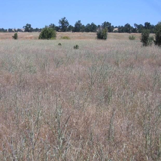
The BLM recently renamed the area an "Outstanding Natural Area", but how natural is it really? The riparian zone close to the river looks pretty natural with a lot of native species of trees, plants and animals. However, the years of cattle grazing have left a serious impact , to the upland areas away from the river. There are many species of non-native plants/noxious weeds such as star thistle, white leaf nightshade, the poisonous Jimson weed and a high density of non-native grasses which people collectively call 'foxtails'. The noxious weed yellow star thistle grows on about 70% of the area and reaches densities between about 12,000 to 179,000 plants per acre. This species has stiff spines and believe me, it's no fun to walk through. I could find no native grasses. Thus most of the ground cover is not natural.
The area still has some very old valley oaks which are wonderful to see but the dense cover of non-native annual grasses prevents normal oak regeneration. Cattle grazing has altered the soil vegetation complex to the point that it would be a challenge to re-establish "natural" native vegetation but not impossible. Unfortunately, the BLM has shown little interest in habitat rehabilitation, so wildlife populations are lower than they should be. Portions of the area are also taking on that "over used public land look" and it is not uncommon to find a dead deer here and there. Evidence of possible poaching. As far as bird hunting goes there are a few turkeys, doves and quail but not in any great numbers. Dove numbers at the area have fallen off over the last 10 years and the habitat for turkeys and quail is limited.
There is a good fishing access at Jelly's Ferry and salmon numbers are up a little. Some of the roads have been improved and hiking trails are marked. Folks ride horses out there but mostly keep to the trails because of the thorny star thistle.
In summary, if you ever have a chance to take a boat trip on the river through the area by all means do it. That's the most natural portion left over from all the impacts the land has suffered.
The rest of the area can certainly provide some recreation but it is not very natural.
We are 100% volunteer and depend on your participation to sustain our efforts!
Donate

$125.00 donated
in the past month
Get Involved
If you'd like to help with maintaining or developing the website, contact us.
Publish
Publish your stories and upcoming events on Indybay.
Topics
More
Search Indybay's Archives
Advanced Search
►
▼
IMC Network