

From the Open-Publishing Calendar
From the Open-Publishing Newswire
Indybay Feature
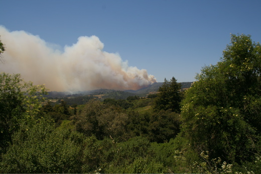
Fire in the Santa Cruz Mountains: Breaking News
800 acres have already burned in the mountains--Summit Road is closed at Mt. Madonna unless you're headed away from the fire which is spreading south as of 8 AM.
KSCO & KPIG report helicopters in the air, a few evacuations, high winds, and heavy smoke in the air.
Add Your Comments
Comments
(Hide Comments)
I have a cam up - you can see a view of the smoke from Gilroy
For more information:
http://www.justin.tv/mtmadonna
...and still burning
As of 12:00 p.m., Closed roads:
Eureka Canyon Road
Corralitos Road
Varni Road
Browns Valley Road
Amesti Road
Pioneer Road
Conditions are extremely windy and clear and the fire has moved fast.
Eureka Canyon Road
Corralitos Road
Varni Road
Browns Valley Road
Amesti Road
Pioneer Road
Conditions are extremely windy and clear and the fire has moved fast.
That's a nice camera feed. You can see how windy it is with the tree, and the smoke billowing. Is that aimed towards the west, so the smoke moving leftwards is going towards the south? I can't quite picture where you are.
Where I am, it was particularly windy yesterday.
One question I had was what the microclimate was where the fire is. The redwoods- Santa Cruz side of the mountain tends to get 10 more inches of rain than western San Jose, and you can sort of see this in their chaparral plants.
Places like Oakland have had S. Calif. style firestorms before, but this was always during autumn Santa Ana winds.
This is a northeast dry wind which is lowering the humidity, but it is impressive to me that one of the areas which tends to be wettest is where the fire is spreading so quickly in May. It almost makes you wonder if a fire would be possible in a spot like Humboldt/S. Oregon.
It's a very dry microclimate in the entire area where the fires are spreading. Native meadow-like, brush-covered lands and VERY dry. There are edges of this area that are surrounded by redwoods, but the majority of the area is very dry and tinder like. Terrible!
Also, from Aptos, as you look down South from Highway 1 just off the Freedom Exit, there is thick smoke that makes visibility very poor.
No word yet as to containment.
Two schools have been dismissed early (PVUSD) and several others are allowing parents to pick up early.
Also, from Aptos, as you look down South from Highway 1 just off the Freedom Exit, there is thick smoke that makes visibility very poor.
No word yet as to containment.
Two schools have been dismissed early (PVUSD) and several others are allowing parents to pick up early.
This map is interesting to look at, if you zoom in on the Monterey area on the pdf, and can then compare with the higher risk San Diego areas. I guess the eastern slope of the mountains are supposed to have higher potential in general, but the area isn't particularly high risk during normal years.
http://frap.cdf.ca.gov/webdata/maps/statewide/fthreat_map.pdf
http://frap.cdf.ca.gov/webdata/maps/statewide/fthreat_map.pdf
May 22, 2008
To: UCSC Community
Fr: Public Information Office
Re: Fire Information
In response to today's fire in the Santa Cruz Mountains, campus staff have
added road and other information to the campus's Emergency Management web
site (http://emergency.ucsc.edu). The site also contains links to local
government information as well as local and regional media sites containing
coverage of the fire.
Please stay informed by visiting that site. Thank you.
To protect students from poor air quality, Pajaro Valley Unified School District will close all schools and district offices.
For more information, see http://www.pvusd.net
For more information, see http://www.pvusd.net
Last night, from moon rocks in Bonny Doon, you could see the orange glow of the fire illuminated in the smoke. As gusts fanned the fire, you could see actual flames leaping hundreds of feet into the air from almost 20 miles away.
Sorry I don't have a photo to share.
Sorry I don't have a photo to share.
wouldn't look so pretty if it was your house in Felton, that was burning http://www.youtube.com/watch?v=IvOH4o54n_M
We are 100% volunteer and depend on your participation to sustain our efforts!
Donate

$190.00 donated
in the past month
Get Involved
If you'd like to help with maintaining or developing the website, contact us.
Publish
Publish your stories and upcoming events on Indybay.
Topics
More
Search Indybay's Archives
Advanced Search
►
▼
IMC Network