

From the Open-Publishing Calendar
From the Open-Publishing Newswire
Indybay Feature
Northern California and North Coast Shales, Natural Gas - Diesel Fracking The Sacramento
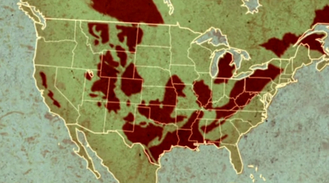
In the northern part of the State, whether coastal or inland, gas basins are non-associated gas basins meaning no-oil is present. The main constituent of the natural gas is methane. The off shore Eel River Natural Gas Basin is comprised of Methane Gas Hydrates, pure methane (nearly) and is technically termed 'dry gas'. Tight-gas, Tight-sands, will it be Acid Stimulation or Frac Fluids and Precious Water Used For Well Stimulation? The map is from Gasland 2. The only map with enough integrity to openly depict the extent of Northern California Non-associated gas fields.
The Monterey Shales produce Oil and Gas, the Franciscan Shales (Northern Coastal Counties) and the Chico Formation of Northern Interior Counties above Sacramento produce mostly dry gas from non-associated gas reservoirs.
The Monterey Shale, the northern extent of which is San Joaquin County, is an oil producing shale formation in which the oil extraction methods produce natural gas liquids. There are many constituents of the wet-gas produced with oil. These are called natural gas liquids. Butane, Propane, are two common ones. Because of 'new' markets for wet-gas liquids, dry gas production from shale has fallen off. Just economics, wet-gas is a by product of oil production.
In other words, the 'lease-held' agreement is for oil, the pay is for the oil. It used to be, that the gas was flared off. Since the oil is paying for the well, the liquids production profit margin causes a price differential that makes un-associated dry-gas wells in the northern part of the state uneconomical to produce. That doesn't mean many wells aren't drilled, and shut-in, awaiting an economic climate that will allow for completion of the well for production.
Will It Be Acid Stimulation or Frac Fluids and Precious Water Used For Well Stimulation?
In the northern part of the State, whether coastal or inland, gas basins are non-associated gas basins meaning no-oil is present. The main constituent of the natural gas is methane. The off shore Eel River Natural Gas Basin is comprised of Methane Gas Hydrates, pure methane (nearly) and is technically termed 'dry gas'.
The Point Arena Offshore Oil Basin is different but a similar case in point, an oil basin yes, but not Monterey Shale.
The southern basin edge is upturned and crops out west of the San Andreas fault system in the Gualala area. Three offshore wells drilled in the mid-1960's penetrate the complete basinal section of Paleogene and Neogene rocks. The Neogene section was deposited in this transform setting following the Mendocino triple junction formation and initiation of the ancestral San Andreas fault system. Neogene rocks contain a shallowing-upward sequence that includes the Miocene, Monterey-equivalent Point Arena formation.
The Point Arena basin contains a major, northwest-trending, seismically-defined structural boundary. AAPG Search and Discovery Article #90935©1998
Geology of North Coastal California
"Continuing detailed studies of the Franciscan have created an even more complex picture of its formation. It appears that Franciscan rocks represent not one but several, accreted terrains.
http://www.krisweb.com/hydrol/geology.htm
These separate Franciscan blocks represent the remnants of several oceanic plates that met their end against the edge of the North America. So far, at least nine different blocks or terrains have been identified. Studies of radiolaria contained in the chert, paleomagnetic analysis of limestone and detailed studies of the mineral content of the greywacke sandstones are some of the tools that geologists are using to complete this picture.
The area where Franciscan rocks are seen can be broadly divided into three belts. In the Coastal Belt, a northwest trending zone between Eureka and the Russian River, Franciscan rocks are mainly greywacke and shale sequences that are not disrupted as other parts of the Franciscan Formation.
The Central Belt, including the San Francisco Bay Area, is found east of the Coastal Belt and this part of the Franciscan Assemblage is a jumble of rocks. Isolated small blocks of exotic greenstone, blueschist, eclogite, chert or greywacke 'float' in a matrix off highly sheared mudstone. Geologists term this mixture a mélange, adopting a cooking term used to describe a soup that contains floating chunks of goodies. In the Franciscan mélange, the 'soup base' or matrix of sheared mudstone, and the floating chunks are blocks of more resistant rock types."
More Information can be found in the document and web page links provided below:
Harris Quarry Expansion Draft EIR Page 87; County of Mendocino parallel to the coast.
The Franciscan Complex of Jurassic-Cretaceous age.
http://www.co.mendocino.ca.us/planning/pdf/Geology_and_Soils.pdf
Geologic units in Mendocino county, California
http://tin.er.usgs.gov/geology/state/fips-unit.php?code=f06045
The Chico Formation
http://www.bigchicocreek.org/nodes/library/ecr/hydrology_geology.htm
The Big Chico Creek watershed is located in a region that includes the interface between the Sierra Nevada Range to the south, and the remnant volcanic flows of the Cascade Range to the north. Big Chico Creek originates in volcanic rocks, referred to as the Tuscan Formation 4 mil yrs old, the Lovejoy formation at 20 million yrs old, and underlying all is the Chico Formation.
Industry understands the significance of geologic differences.
Along with Occidental Petroleum, Rango Energy, Inc. drilling has reached a depth of 8,556 feet on the planned 13,000 ft. first well at the Kettleman Middle Dome (KMD) project. Drilling is currently turning through the Temblor Sands that lay directly underneath the Monterey Shale.
The drilling passed through a 1,750 foot thick section of the Monterey Shale and will pass through the Temblor Sands, the Vaqueros sandstone, and the Kreyenhagen Shale before reaching the McAdams formation at 12,000 feet. The McAdams sandstone has been a prolific producer in the adjacent Coalinga and Kettleman North Dome, with over 300 wells producing at an average of over 2.7 MMBOE (million barrels equivalent) per well.
http://www.oilvoice.com/n/Rango_Energy_provides_update_on_the_drilling_operations_on_its_Kettleman_Middle_Dome_project_in_California/d3cbf5d091c7.aspx#gsc.tab=0
In a 2008 paper prepared for a meeting of the Society of Petroleum Engineers, Pinnacle Technologies reported the fracking process "has been applied to a large scale in many Central and Southern California fields to enable economic development and reasonable hydrocarbon recovery. Example formations include the Belridge Diatomite, Stevens Sands, Etchegoin, Antelope shale, McLure shale, McDonald shale, Point of Rocks sands, Kreyenhagen shale, Ranger sands, the UP Ford Shale, and the Monterey shale.”
It also stated that "based on the initial experience and formation properties, it is believed that hydraulic fracturing has a significant potential in many Northern California gas reservoirs.” El Shaari, N., W.A. Miner, "Northern California Gas Sands - Hydraulic Fracture Stimulation Opportunities and Challenges," SPE Western Regional and Pacific Section AAPG Joint Meeting, Bakersfield, CA March 31-April 2, 2008.
Acidizing
http://www.sourcewatch.org/index.php?title=California_and_fracking#cite_note-8
Acidizing, also referred to as “matrix acidization,” typically involves the injection of high volumes of hydrofluoric acid, a powerful solvent (abbreviated as “HF”) into the oil well to dissolve rock deep underground and allow oil to flow up through the well. Conventional fracking, in which water and other chemicals are pumped at high pressure to create fissures in the rocks, reportedly does not work well in many parts of the Monterey Shale. Acidizing, in contrast, is popular in California because the oil-bearing shale is already naturally fractured and buckled from tectonic activity.
Hydrofluoric acid corrodes glass, steel, and rock. Drillers have been injecting it underground for years in diluted quantities (up to 9% HF) to get out the last bits of oil from nearly depleted wells, and injecting in stronger concentrations to dissolve oil-bearing shale. The concentrations of HF acid used by oil companies are unknown, as is what happens over the long term to the rock, and to the HF acid-laced water. SB4, California's new Well Stimulation Regulations do not regulate except by incrementally small additional language, acid fracking and formation (matrix) acidizing, when above a 7% mixture.
Monterey, Kreyenhagen, Bakken, Eagle Ford Shales
The Bakken and Eagle Ford shales are approximately 360 and 90 million years old, respectively, and were deposited on a relatively stable platform; as a result they are thin and widespread, and hence are relatively predictable. The Monterey is 6-16 million years old and was deposited rapidly in an active tectonic regime; as a result it is thick, of limited areal extent, and structurally complex, and hence is much less predictable. An analysis of oil production data from the Monterey Formation reveals the following:
1) While tight oil plays generally produce directly from widely dispersed source rocks or immediately adjacent reservoir, as is the case in the Bakken and the Eagle Ford, this is not the case in the Monterey Formation, where most production has come from localized conventional reservoirs filled with oil that has migrated from source rock.
2) 1,363 wells have been drilled in shale reservoirs of the Monterey Formation. Oil production from these wells peaked in 2002. As of February 2013 only 557 wells were still in production.
3) Most wells appear to be recovering migrated oil, not “tight oil” from or near source rock as is the case in the Bakken and Eagle Ford plays. The EIA/INTEK report assumed that 28,032 tight oil wells could be drilled over 1,752 square miles (16 wells per square mile) and that each well would recover 550,000 barrels of oil. Data suggests, that these assumptions are optimistic.
http://www.scribd.com/doc/187711217/Drilling-California-A-Reality-Check-on-the-Monterey-Shale
The US Office of Energy Administration (a division of the US Government Office of Energy) estimates that almost 2/3rds (64%) of all the oil shale resources in the contiguous United States are located in California.
http://www.gulfoilandgas.com/webpro1/MAIN/Mainnews.asp?id=19104
Those same published statistics show that the San Joaquin Basin, is in turn the volumetrically richest of the California oil shale basins. The two main oil shales are the Monterey Shale, and the Kreyenhagen Shale, which is thick and extensive.
Targeting the oil shales in the northern part of the San Joaquin Basin, particular emphasis is on the Kreyenhagen Shale where it is not too deeply buried and should not be expensive to exploit. The shale formation outcrops to the west in the project area and plunges down to approximately 11,000 feet in the east.
Miocene Monterey
http://www.oilshalegas.com/montereyshale.html
The Kreyenhagen Shale is a viable exploration target with potential for development with horizontal well technologies. These technologies, now standard for oil shale reservoirs elsewhere, are yet to be tried in the project area or, as far as the Company is aware, in the adjacent fields that are producing light oil from vertical wells.
Occidental Petroleum Corporation (US$84billion) has ambitious plans for the expansion of its oil shale production in California and are the largest acreage holder adjacent to Solimar. OXY is competitively leasing in the immediate area of Solimar’s Kreyenhagen Project.
New Gulf Resources, a private company from Tulsa, Oklahoma is in the process of drilling an initial three well program on acreage on the flanks of the Kettleman Domes with targets in both the Monterey and Kreyenhagen Shales.
Hess Corporation (US$22 billion), a new entrant into the California oil shale plays has been permitted for the drilling of up to 6 test wells updip to the east from Zodiac Exploration’s acreage and deep horizontal well. Hess will be targeting the Kreyenhagen Shale.
Who is HESS?
John B. Hess, Chief Executive Officer of Hess, said, “The sale of our Utica dry gas acreage is an example of our continued commitment to grow shareholder value through ongoing portfolio reshaping. While our wells in the dry gas portion of the Utica were highly productive, we concluded that the potential returns from such an investment, at current and projected natural gas prices, no longer justified retaining this acreage as a strategic part of our overall liquids-based asset portfolio.”
http://www.gulfoilandgas.com/webpro1/MAIN/Mainnews.asp?id=32987
The northern extent of the Monterey Shale - Sourcewatch:
http://ftp.sourcewatch.org/index.php?title=California_and_fracking
North of the Monterey Shale; the Sacramento Basin is a major gas producing area located in northern California. In 2002, the region produced 81 billion cubic feet of gas from 83 fields and more than 1,000 producing wells. The Knights Landing field which was discovered in 1981 and has produced more than 20 billion cubic feet of natural gas.
The Willows and Greater Grimes fields are located in Colusa, Glenn and Sutter Counties north of Sacramento, California. Depths range from 2,800 feet in the Willows field to 8,900 feet in the Greater Grimes field. 439 wells in the fields producing as of December 31, 2008. The huge Rio Vista Gas field extends into Solano, Sacramento and Contra Costa Counties.
20 Tears Of Diesel Fracking, In The Sacramento Valley
*continuing after 2004 EPA/California Primacy MOA under the UIC of the SDWA
In 2010, Oil & Gas (O&G) industry representatives claimed that diesel was no longer used in hydraulic fracturing operations, but there was increasing evidence that the use of diesel remained widespread. In early 2011, an investigation by members of the U.S. House of Representatives found that drilling service companies injected over 32 million gallons of diesel underground during hydraulic fracturing between 2005 and 2009.
Injecting diesel underground is problematic because of the toxic chemicals it contains, especially the “BTEX” compounds. “BTEX” refers to benzene, tolulene, ethylbenzene and xylene. These chemicals are linked to numerous adverse health effects including cancer, kidney and liver problems and nervous system damage. They are toxic at very low levels and are soluble in water, which is of particular concern when injecting them into the ground in proximity to underground sources of drinking water.
The three leading providers of fracturing services had already signed a "memorandum of agreement," or MOA in 2004 with EPA not to use diesel. Halliburton, BJ Services and Schlumberger then accounted for 95 percent of the "frack jobs" in the country.
But the EPA agreement with service providers covered only a narrow set of circumstances drilling into underground sources of drinking water to get methane from coal beds. So a driller could legally inject diesel for most types of fracturing. The driller just needed to get an "underground injection control" permit from EPA or state regulators.
The earliest mention I found for Diesel Frac Fluid was 1978.
In Jan 20, 2004 near Sacramento, Tri-Valley Corporation re-perforated a 1,000-foot section in its Sunrise-Mayel 2HR in preparation for re-fracturing using diesel oil. Tri-Valley Corporation announced that it commenced operations to re-enter its Sunrise-Mayel No. 2HR and hydraulically fracture the McClure Shale formation with diesel oil. “The target zone (is) non-water-bearing and not connected with any aquifer.”
Jul 19, 2004
Tri-Valley Corporation announced that it has confirmed that a diagnostic hydraulic fracture process on its Ekho deep well indicated a successful breakdown of the Vedder Sand formation at the 18,000- to 18,500-foot-level and provided important information for designing the main "frac" job to be done on the well.
September 7, 2004
Made preparations to hydraulically fracture its Ekho No. 1 deep well below 18,000 feet, Tri-Valley continued exploiting the Sunrise Prospect to access what was estimated to be an exceptional natural gas find. Other wells several miles from the Sunrise area had been successfully produced, but no well in California like the Ekho No. 1 deep well had ever been fracked. Tri-Valley is pioneered completion programs on both discovery wells.
The map at the top is one from the film Gasland. Notice the depicted extent into Northern California of non-associated 'un-conventional' natural gas reservoirs. Conventional reservoirs, are small in volume but easy to develop, unconventional reservoirs are large in volume but difficult to develop.
Wet or Dry defined:
http://www.glossary.oilfield.slb.com/en/Terms.aspx?LookIn=term%20name&filter=dry%20gas
1. n. [Geology]
Natural gas that occurs in the absence of condensate or liquid hydrocarbons, or gas that has had condensable hydrocarbons removed. Dry gas typically has a gas-to-oil ratio exceeding 100,000 scf/STB. The gas-oil ratio is an important indicator of reservoir energy and the determination of gas resources in a petroleum deposit.
2. n. [Well Completions]
Gas produced from a well that produces little or no condensate or reservoir liquids. The production of liquids from gas wells complicates the design and operation of process facilities at the surface required to handle and export the produced gas.
What’s the difference?
http://stateimpact.npr.org/pennsylvania/2012/01/26/what-makes-wet-gas-wet/
Natural gas is a gas comprised of multiple hydrocarbons, the most prevalent being methane. The higher the methane concentration, the “drier” or “colder” the gas is. Other constituents of natural gas are evaporated liquids like ethane and butane, pentane, etc. We refer to these collectively as natural gas liquids (NGLs), or “condensates”. The higher the percentage of NGL’s, the “hotter” or “wetter” the gas is. NGL’s must be stripped out of the gas before it can be put in a pipeline and used. Ethane, which is prevalent in Western PA wet gas, is the feedstock for Ethylene, which is used to make plastics.
The NGL’s are worth considerably more than dry gas. In some areas, the value of the gas is more than doubled because of the NGL’s. Right now, the commodity price for natural gas is very low due to an oversupply situation.
Hydraulic Fracturing And Horizontal Drilling
The methods for extracting gas from tight sand formations are analogous to those methods used for extracting gas from shale. Hydraulic fracturing and horizontal drilling are essential in most formations.
http://www.ogfj.com/unconventional/tight-gas.html
Conventional reservoirs are those that can be produced at economic flow rates and that
will produce economic volumes of oil and gas without large stimulation treatments or any
special recovery process. A conventional reservoir is essentially a high- to medium permeability
reservoir in which one can drill a vertical well, perforate the pay interval, and then produce the well at commercial flow rates and recover economic volumes of oil and gas.
An unconventional reservoir is one that cannot be produced at economic flow rates or that does not produce economic volumes of oil and gas without assistance from massive stimulation treatments or special recovery processes and technologies, such as steam injection.
Typical unconventional reservoirs are tight-oil shales,
tight-gas sands, coal-bed methane, heavy oil, and tight-gas shales.
The term tight gas sands refers to low-permeability sandstone reservoirs that produce primarily dry natural gas. A tight gas reservoir is one that cannot be produced at economic flow rates or recover economic volumes of gas unless the well is stimulated by a large hydraulic fracture treatment and/or produced using horizontal wellbores. This definition also applies to coalbed methane, shale gas, and tight carbonate reservoirs. Tight sands produce about 6 tcf of gas per year in the United States, about 25% of the total gas produced.
Tight Gas Sands
http://jmccas1.hubpages.com/hub/Unconventional-Resources
“Tight gas” refers to natural gas produced from reservoirs that have very low porosities and permeabilities. Reservoirs are usually sandstone, although carbonate rocks can also be tight-gas producers. The standard industry definition for a tight-gas reservoir is a rock with matrix porosity of 10% or less and permeability of 0.1 millidarcy or less, exclusive of fracture permeability.
What is a Tight Gas Reservoir?
“Tight gas” lacks a formal definition, and usage of the term varies considerably. Law and
Curtis (2002) defined low-permeability (tight) reservoirs as having permeabilities less
than 0.1 millidarcies. Therefore, the term "Tight Gas Reservoir" has been coined for
reservoirs of natural gas with an average permeability of less than 0.1 mD (1 x 10-16 m²).
A Tight Gas Reservoir is often defined as a gas bearing sandstone or carbonate matrix
(which may or may not contain natural fractures) which exhibits an in-situ permeability
to gas of less than 0.10 mD.
Tight Gas Reservoir Distribution: Types of Tight Gas reservoirs Onshore or Offshore
Many think of tight or low-permeability reservoirs as occurring only within basin-centered, or deep basin settings. However, tight gas reservoirs of various ages and types produce where structural deformation creates extensive natural fracture systems whether it is basin margin or foothills or plains. Fractured, tight and unconventional reservoirs can occur in tectonic settings dominated by extensional, compressional or wrench faulting and folding. Late burial diagenesis of the sandstone may also result in tight reservoirs. Although "tight gas sands" are an important type of basin-centered gas reservoir, not all of them are Basin-centered gas systems (BCGAs).
What Is A Basin-Centered/Deep Basin Gas System?
Basin-centered gas/Deep Basin (>15,000ft) accumulations are a component of BCGSs that is defined as "an abnormally-pressured, gas-saturated accumulation in low-permeability reservoirs lacking a down-dip water contact". They are characterized by regionally pervasive gas-saturated reservoirs, containing abnormally-pressured gas accumulations.
In southern Mendocino County, the Point Arena Basin holds enormous quantities of oil. 90% of the Eel River Basin in Humboldt County is Offshore.
Basin-Centered Gas: In conventional gas exploration, geo-scientists look for traps and seals. For unconventional tight-gas exploration, however, a basin-centered gas play is most desirable. These regionally extensive gas systems are essentially water-free, with over-pressured gas in low-permeability sands or shales. Such systems experience relatively high decline rates during initial production, but stabilize at very low decline rates, resulting in long-life reserves.
Township Drainage, Well Clusters and Onsite Waste Management are key components of New Technology Concepts for tight gas development. “An enormous volume of unconventional oil and gas will be there to fill the gap once conventional oil begins to decline.”
Both Mendocino and Humboldt Counties have vast reservoirs of oil or natural gas hydrates most of which are just offshore, but development is already underway onshore in Humboldt County with 12,000 acres under lease to tap the Eel River Basin for Natural Gas Hydrates. At least one exploratory well has reached approximately 9,500 feet depth, and producing zones are expected at 4,000 to 6,000 feet and at 9,400 feet. “Production wells will employ fracture stimulation techniques”.
In the southern onshore region of the Eel River Basin, geologically recent west-east-striking faults and folds are superimposed on top of older north- to northwest-trending structures formed as a result of Gorda-North American plate convergence (Clarke, 1987; Nilsen and Clarke, 1987). Seismologically, this is a very active region, and most earthquake hypocenters occur at depths of less than 20 km (Smith and Knapp, 1980).
In southern Mendocino County, the Point Arena Basin holds enormous quantities of oil.
90% of the Eel River Basin in Humboldt County is Offshore
The Mendocino Coast may no longer remain protected from offshore oil. Well maybe offshore oil development and the onshore facilities that support that offshore oil development. That's how the protections read. Local ordinances in the General Plan of Mendocino and the Coastal Element might not adequately cover onshore development of natural gas zones, or access to offshore basins for extraction of Natural Gas Hydrates.
In the 80's un-associated or non-associated gas fields (not associated with oil), were not even considered. As recently as March 21, 2013 DOGGR would not use the term in presentations throughout the State, and dismissed queries amid discussion regarding the locations and production levels of non-associated gas wells in Northern California. A gas field is generally comprised of a number of wells.
Deviant, Slant, Under Balanced, Directional, Horizontal Drilling;
Partial and Full Aquifer Exemptions, SDWA/UIC Permitted Contamination
Forced Pooling and Unitization Of Adjacent Lands Bind Surface Property Rights To Reservoir
boundaries under Oil and Gas Protections in law which serve to promote production of oil and/or gas resources at any cost. To every good law of the land, anywhere, there are exemptions for O&G everywhere.
Since the advent of directional drilling, oil companies have eyed the oil and (or) gas reservoirs under State waters and tried to find access to them from onshore or from Federal waters. As we shall see the California educational system has strong ties to the industry. The Redwood Curtain is now in service to Oil and Gas Corporations.
Wednesday, November 3, 2004 from Bakersfield to Houston it is known:
"Tight Gas Sands of the Eel River Basin, California." Jere Jay, INNEX/FOREXCO Energy
http://www.beg.utexas.edu/pttc/archive/nov3-2004-unconventional.htm
But if we visit the online the Humboldt State University Library, Energy and Mineral Resources Section: "This research guide lists both print and Internet maps that cover northwestern California. The table of contents below lists maps by theme and environment." But there are no entries for Energy and Mineral Resources. The only listing with no entries! Seems odd with all the interest in Natural Gas Hydrates and leases.
HSU Library “Energy & Mineral Resources”
http://library.humboldt.edu/infoservices/staff/rls/geospatial/nwcalmaps.htm#energy
Yet, up river, the California Eel River basin drilling nears 06/19/2007
http://www.ogj.com/articles/2007/06/california-eel-river-basin-drilling-nears.html
Three or more wells could be drilled later this year in northwestern California's remote Eel River basin southeast of Eureka. The Bakersfield, California based Foothills Resources Inc., shot 13 sq miles of 3D seismic early in 2007 and controls the 'lease-held' agreements on 12,000 acres surrounding the Grizzly Bluff field in Humboldt County. The Grizzly Bluff #4 well reached a total depth of 9,530 feet on March 24, 2008.
http://www.prnewswire.com/news-releases/foothills-resources-inc-announces-well-tests-in-california-57458537.html
Foothills also accumulated a controlling leasehold position 7 miles northwest of Grizzly Bluff near abandoned Table Bluff gas field. Since 2006, Foothills has acquired additional oil and gas leases in the Eel River Basin, and currently has interests ranging from 70% to 75% in approximately 12,000 additional gross leasehold acres over seven prospects with no depth restrictions.
Now I don't know why academia didn't share this next one! “Our studies show abundant subsurface gas... Analysis of seismic data in the Eel River basin shows that although natural gas in this area is abundant, it is regionally variable and controlled more by stratigraphy than by structure. The abundant gas detected in this basin may affect sediment strength and slope stability, altering both seafloor morphology and sediment transport.”
http://www.dtic.mil/dtic/tr/fulltext/u2/a348384.pdf
ONR Grant N000014-96-1-0361 Final Technical Report:
Seafloor Geomorphology, Gas and Fluid Flow, and Slope Failure on the
Southern Cascadia Continental Margin; Daniel L. Orange
Deptartment of Earth Sciences, University of California, Santa Cruz, CA 95064
The Humboldt General Plan lists Natural Gas Resources in Humboldt County
http://www.ci.eureka.ca.gov/civica/bids/inc/blobfetch.asp?blobID=3438
There are natural gas deposits present in Humboldt County. Active gas wells are concentrated in the Tompkin Hills Gas Field. Of the County’s 39 gas wells, 31 are currently producing and 8 are considered shut in, meaning they cannot produce gas at their current depths and are sealed off in order to maintain the pressure on remaining deposits. In 2000, net gas production was 1,337,796 million cubic feet (mcf); this represents a 31 percent decrease in gas production since 1992, when net production was 1,927,787 mcf. It further states that in 1992, 34 gas wells were in production and 5 were shut in. Humboldt County contains three inactive oil wells and has not produced oil in at least the past ten years.
FOREXCO, Inc. of Greensboro, NC, secured a 20-year lease (through 2022) to engage in the exploration of natural gas in Humboldt County on the east and west side of the Eel River near Alton to determine potential natural gas reserves. As part of this lease, they have the rights to the exploration and operation of up to five previously developed well sites that have the potential for up to five wells per site. FOREXCO proposed to construct a natural gas collection and transportation system that would cross the Eel River and interconnect with the existing gas sales delivery point at the Pacific Gas and Electric Company’s (PG&E) natural gas meter station in Alton. The pipeline will be designed to operate at a maximum allowable operation pressure of 1,360 pounds per square inch (psi). The design of the project allows for greater capacity for possible future development of natural gas reserves west of the Eel River.
http://www.co.humboldt.ca.us/planning/gp/meetings/natl_res/nr_report.asp
What is the significance of access to the Eel River Basin offshore Natural Gas Hydrates?
Methane (Natural Gas) Hydrates in offshore subduction zone sediments hold the world's largest reserves of Natural Gas. More than all combined known global shale gas reserves. Not all coastlines share this geologic feature. The Eel River Basin (offshore) is important enough to be shown on the Global Inventory of Methane Deposits.
http://geology.com/articles/methane-hydrates/
And just for the historical record, 60km off the coast at Crescent City, July 1996 a drilling survey of Offshore Natural Gas Hydrates (in marine sediments, sandstones) was mapped. “This informal report was prepared from the shipboard files by the scientists who participated in the cruise. Preliminary Report No. 67, First Printing 1996.
http://www-odp.tamu.edu/publications
OCEAN DRILLING PROGRAM CALIFORNIA MARGIN
http://www-odp.tamu.edu/publications/prelim/167_prel/167prel.txt
LEG 167 PRELIMINARY REPORT: Leg 167 drilled 13 sites along the climatically sensitive California Margin. Site 1019 (Proposed Site CA-1D)
Site 1019 is located about 60 km west of Crescent City, California, in the Eel River Basin at a water depth of 983 mbsl (Fig. 1). It is the nearshore site of the Gorda Transect. One of the important objectives at this site was to sample gas hydrates. A high-resolution pore-water sampling program was carried out to detect evidence of gas hydrate formation. A logging program was added to measure the extent of gas hydrate formation in situ (permeability).
But the HSU Library mentions not a single resource under Minerals and Energy!
Point Arena Offshore Oil and Gas Basin, Mendocino County
The bulk of natural gas reserves off the California coast, estimated at some 17 trillion cubic feet, are in areas where they often coexist with oil deposits, and therefore can not be touched unless the state were to specifically agree to open those federal waters to oil drilling.
1987 NO OFFSHORE OIL North Coast Moratorium:
The proposed lease sale in 1987, thwarted by the moratorium, would have opened 6.5 million acres off the North Coast. Off Mendocino and Humboldt counties, the tracts for sale lay from 3 to 27 miles offshore, and some of the 24 planned platforms at 300 feet tall and each with dozens of wells, would have been visible from land.
Tourism and commercial fisheries would have been affected, according to an environmental review then, while as many as 240 new oil tanker trips from Fort Bragg and Eureka to San Francisco Bay refineries were predicted. The probability of one or more spills occurring would be 94 percent for accidents involving 1,000 barrels or more, according to documents.
http://www.sfgate.com/cgi-bin/article.cgi?f=/c/a/2008/12/28/MN4G14QMVE.DTL#ixzz0WKVRptL0
In 2005, a US panel backed offshore gas drilling
http://www.resilience.org/stories/2005-09-29/other-energy-headlines-30-september-2005#
Sacramento Bee September 29, 2005 Two areas off California's coast could be exploited quickly if the bill passes.
WASHINGTON: A House committee voted Wednesday to end long-standing moratoriums that have prevented opening new areas off the coast of California and other states to natural gas development.
If enacted into law, the provision could immediately open for development the Eel River basin in Northern California and the smaller Pitas Point gas field in the Santa Barbara Channel.
The federal Minerals Management Service estimates that there is some 2 trillion cubic feet of natural gas in those deposits, mostly in the Eel River area, in Humboldt County, California.
Northern California Rivers Flow Into Frac Wells And Steam Injection Wells
Canadian Technology In The Monterey Shale, September 2006
Water Usage By Steam Injection Vaca Tar Sands At Oxnard, CA
Old, conventional recovery methods have typically recovered in the range of 25% in the heavy oil interval and new methods suggest double that or more may be achievable according to experts. Tri-Valley could eventually drill as many as 20 dual horizontal wells. Called SAG-D for steam assisted gravity drainage, the wells involve sets of upper and lower horizontal well bores with continuous steaming being injected into the over bore to help the heavy oil drain into the under bore for recovery. Tri-Valley acquired its first 25 million BTU steam generator for use on the Vaca wells.
http://www.rigzone.com/news/oil_gas/a/36104/TriValley_Begins_Operations_in_Pleasant_Valley
Tri-Valley Corporation successfully completed the first extended steam cycle on two of seven horizontal wells at the company's Pleasant Valley heavy oil project in Oxnard, California. Peak rates for the project's heavy oil lease have temporarily reached 1,000 barrels of oil per day (BOPD). The company initiated a second cycle on two additional wells at the site. Steam Assisted Gravity Drainage (SAGD) technology materially increases well recovery.
http://www.rigzone.com/news/oil_gas/a/93063/TriValley_Sees_93_in_Revenues#sthash.DIYtmD4T.dpuf
Steam Injection Is Literally Global Warming
Watch the video,
This American Land; Mixing Oil And Water: 4 min
http://www.youtube.com/watch?v=d6I0wcCpEJg&feature=youtu.be
Steamed Earth GHG Emissions, AB 32, And Streamlined Environmental Laws
Out west in California, one company, in one oil field each day uses 60 million gallons of water per day from the California Aqueduct and injects it as steam into wells in a process not covered by SB 4 Well Stimulation Regulations, called Steam Injection. Cyclic steam injection repeats this process for a week or more at a time, when the ground cools slightly, production begins and oil flows up out the well. When production falls off, the process is repeated.
If only applied 12 weeks in a year, that's 5 billion gallons allocated from the California Aqueduct, taken from the aquifers, rivers and watersheds of the northern part of the State.
The math below is pretty close, though slightly rounded.
1.4 million barrels a day. 42 (gallons) x 1.4 million is 58,800,000 almost 60 million gallons. That's 184 acre feet each day. A seven day cycle equals 1288 acre feet of water usage, and with 12 cycles per year, that's 15,456 acre feet of water per year turned to steam, and injected underground in one oil field. Compared to the water usage of a single family of four, in a 3 bedroom household, that's roughly equivalent to the yearly water usage of 700-1000 families in California, each day. In one week, a quantity of water which could serve the yearly needs of 5,000 – 7,000 California families is pumped down into the ground, as steam.
The steam/water comes back out with the oil, as produced water. As production falls off, steam injection is again applied, hence the term “Cyclic Steam Injection”. That means that in one year, in one oil field in California, the quantity of water used to steam the earth would serve 60,000 to 70,000 households (single family of four, 3 bedroom) including landscape needs.
Yet in the 2011 report issued by the Public Policy Institute Center, as elsewhere, water usage by oil and gas operations in the state is never mentioned; not even once.
Managing California’s Water From Conflict to Reconciliation
© 2011 by Public Policy Institute of California.
http://www.ppic.org/main/publication.asp?i=944
At least the document includes a topographical map of groundwater aquifer basins in California on page 193, adjudicated basins DWR Bulletin 118 Aquifers
http://www.ppic.org/content/pubs/report/R_211EHR.pdf
505 pages full report 8 MB download
As in the document, and on any day, in any broadcast or drought related news story, water usage by oil and gas operations in the state is never mentioned; not once.
In the 505 page PPIC report, the only use of the term 'natural gas' occurs under the heading “Water As A Commodity”. It states that “the broad economic and environmental effects of storing, moving, and using water make it necessary to regulate these functions to protect public values. But water is also a commodity, an input into the production of goods and services, with a price and a market value, much like electricity or natural gas.”
Why is it, that oil and gas production is seemingly non-existent in the State of California according to the Public Policy Institute of California 2011 report “Managing California’s Water From Conflict to Reconciliation”?
One answer is that the Resources Legacy Fund Foundation, along with the Stephen Bechtel Jr. Foundation and the David and Lucile Packard Foundation, fund the Public Policy Institute of California (PPIC) studies advocating the construction of the peripheral canal and twin tunnels. The RLFF and Packard Foundation along with the Gordon and Betty Moore Foundation funded the Marine Life Petroleum Act. The deception and intrigue run deep, BIG story.
Tomas DiFiore
Add Your Comments
We are 100% volunteer and depend on your participation to sustain our efforts!
Donate

$255.00 donated
in the past month
Get Involved
If you'd like to help with maintaining or developing the website, contact us.
Publish
Publish your stories and upcoming events on Indybay.
Topics
More
Search Indybay's Archives
Advanced Search
►
▼
IMC Network